


Maps
Friday Eye Candy: 40 More Maps That Explain Everything
It's hard to keep up with the endless quest to present the world's knowledge in map form, but luckily we've got Max Fisher as a guide. He's collected 40 more fascinating maps that explain world history, present conditions and future scenarios.
Exploring the Mental Terrain of Ancient Mapmaking
A new exhibition on Greco-Roman mapmaking at the Institute for the Study of the Ancient World in New York examines the relationship between geographic and metaphysical world views.
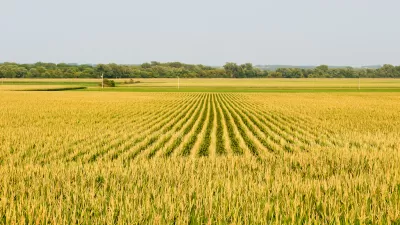
Where America Grows: Mapping the Country's Crops
Did you know that sweet potatoes are only produced in a small area of North Carolina? Or that flaxseed is only grown in the country's remote northern reaches? Crop maps published by the USDA paint an interesting picture of American agriculture.
Help Pick Boston's Next Transit Map
The six finalists in an open competition to design Boston's next subway map have been revealed, and the Massachusetts Bay Transit Authority (MBTA) is asking the public to weigh in on the winner.
A Never-Ending Map Of Imaginary Cities
Artist spends decades creating an always-growing hand-drawn paper map of an imaginary place. Development is determined by drawing a random card from a custom deck of cards.

World's Oldest New World Globe Found on an Ostrich Egg
A collector has discovered the world's oldest globe to depict the New World, which may have originated from Leonardo da Vinci's shop in 1504.
Fascinating Friday: 80 Maps That Explain Everything
The battle over who can present the most compelling infographical maps is apparently escalating. The good news, no matter the result, we all win. While these 80 maps may not explain everything, they sure do say a lot.
Unrealized City Plans a Window on a Future That Would Not Be
Blogger Andrew Lynch’s collection of unrealized city plans is a catalog of could-have-beens.

Mapping Interest in All Things Zombie
The three geographers behind the Floating Sheep blog have created a world map of Internet references to zombies.
Friday Eye Candy: 19 Fascinating City Maps
Lauren Drell at Mashable has rounded up 19 (or is it 21?) 'dynamic, real-time and compelling visualizations of how we live and move.'
Massive Historical Map Collection Added to Digital Library
A private collection of 38,000 historical maps has been added to the Digital Public Library of America, reports Rebecca Rosen, making it more accessible to researchers and anyone interested in the history of their community.
Can an Upstart Mapmaker Beat Google and Microsoft at Their Own Game?
Glenn Fleishman profiles MapBox, whose 30 employees are taking on the big boys in the development of interactive street and satellite maps. The company is working with Charlie Loyd to develop "the most beautiful, clean map ever made."
An Elegant Guide to Walkability
The Spanish city of Pontevedra has developed an innovative, and attractive, map of pedestrian connections based on the color-coded subway maps common to cities around the world; burnishing its reputation as "a leader in walker-friendly urban policy."
Friday Funny: Map Madness
BuzzFeed has gathered 38 prime examples of "maps you never knew you needed." And while some are fascinating (such as how much space the world's population would take up if everyone lived in one city) others are just Ludacris.
Belligerent Map Campaigns
Old and new maps take center stage in China's effort to lay claims to disputed territories.
The Quest to Build the Best Map
Why are Google, Apple, Nokia, and Microsoft funneling significant resources into creating the best digital maps? "[A]ll share the same hunch that maps sit at the core of our digital future," writes Farhad Manjoo.
NYC Facilitates Walking with New Wayfinding Maps
One out of ten New Yorkers gets lost every week, according to the city's Department of Transportation, and this does not include out-of-towners. In March, the city will begin installing 150 wayfinding signs to help pedestrians navigate their way.
New Map Shows How to Traverse California via Public Transit
For those that dream of traveling the length of the Golden State without getting behind the wheel of an automobile, a new map shows the interconnected system of trains and buses that can get you from San Diego to Eureka and in-between.
A New Tool for Those Searching for a Similar Sense of Place
A new program developed by University of Cincinnati Professor Tomasz Stepinski allows users to find sections of the American landscape with similar land coverage or ecological patterns.
Innovative Map Shows Estimated Time of Arrival for Entire Regions
Want to know how long it will take to pick up the kids at school, drive to your favorite restaurant, drive the baseball game, take the bus to the park? And all at once? Trulia's new innovative map does just that.
Urban Design for Planners 1: Software Tools
This six-course series explores essential urban design concepts using open source software and equips planners with the tools they need to participate fully in the urban design process.
Planning for Universal Design
Learn the tools for implementing Universal Design in planning regulations.
Heyer Gruel & Associates PA
Ada County Highway District
Institute for Housing and Urban Development Studies (IHS)
City of Grandview
Harvard GSD Executive Education
Toledo-Lucas County Plan Commissions
Salt Lake City
NYU Wagner Graduate School of Public Service


