


Artist spends decades creating an always-growing hand-drawn paper map of an imaginary place. Development is determined by drawing a random card from a custom deck of cards.
Since 1963, Jerry Gretzinger has been drawing and painting an ever-growing paper map filled with imaginary cities, rivers, lakes, railroads, airports, highways, & farmlands. He uses a photocopier, pens, and paints and keeps track of the growing map's over 2600 "tiles" in a spreadsheet.
"Now Jerry uses a specially crafted deck of cards to determine the outcome of his world, with fictitious cities like “Plaeides,” “Wybourne” and the largest, “Ukrainia.” Each day he draws cards to see how a page of his gigantic map will be modified, with perhaps the most unusual card being the 'void.' With this card a blank spot is put on the map, wiping out previous details completely and opening up a world of new possibility. "
The map was on exhibit at the Massachusetts Museum of Contemporary Art in 2012. A zoomable version of the map is available online.
FULL STORY: VisualNews


Opinion: Enhancing Inclusive Development: The Crucial Role of the Creative Class in Urban Planning
How bringing local artists into the development process can foster more vibrant, equitable neighborhoods.

How the National Park Service Uses GIS
A new book demonstrates how the National Park Service uses GIS technology to meet its mission and showcases a selection of maps used for effectively managing national parks.
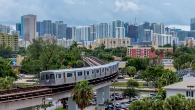
New Tool Puts Miami Development Opportunities on the Map
There's plenty of vacant or underutilized land to be found in Miami-Dade County, if you know where and how to look.

Alabama: Trump Terminates Settlements for Black Communities Harmed By Raw Sewage
Trump deemed the landmark civil rights agreement “illegal DEI and environmental justice policy.”

Planetizen Federal Action Tracker
A weekly monitor of how Trump’s orders and actions are impacting planners and planning in America.

The 120 Year Old Tiny Home Villages That Sheltered San Francisco’s Earthquake Refugees
More than a century ago, San Francisco mobilized to house thousands of residents displaced by the 1906 earthquake. Could their strategy offer a model for the present?

In Both Crashes and Crime, Public Transportation is Far Safer than Driving
Contrary to popular assumptions, public transportation has far lower crash and crime rates than automobile travel. For safer communities, improve and encourage transit travel.

Report: Zoning Reforms Should Complement Nashville’s Ambitious Transit Plan
Without reform, restrictive zoning codes will limit the impact of the city’s planned transit expansion and could exclude some of the residents who depend on transit the most.

Judge Orders Release of Frozen IRA, IIJA Funding
The decision is a victory for environmental groups who charged that freezing funds for critical infrastructure and disaster response programs caused “real and irreparable harm” to communities.
Urban Design for Planners 1: Software Tools
This six-course series explores essential urban design concepts using open source software and equips planners with the tools they need to participate fully in the urban design process.
Planning for Universal Design
Learn the tools for implementing Universal Design in planning regulations.
Clanton & Associates, Inc.
Jessamine County Fiscal Court
Institute for Housing and Urban Development Studies (IHS)
City of Grandview
Harvard GSD Executive Education
Toledo-Lucas County Plan Commissions
Salt Lake City
NYU Wagner Graduate School of Public Service