


The Spanish city of Pontevedra has developed an innovative, and attractive, map of pedestrian connections based on the color-coded subway maps common to cities around the world; burnishing its reputation as "a leader in walker-friendly urban policy."
Eduardo Ares discusses Pontevedra's award-winning Metrominuto map, the latest effort by city leaders to protect their historic streets from oppressive automobile traffic, and promote non-motorized transportation. Past efforts have included widening sidewalks, establishing a free bike-lending service, and banning motorized transport in sections of the city.
"To further improve walkability," explains Ares, "Pontevedra's city council produced a map that visualizes the distances and travel times between key places on foot at an average speed of five kilometers per hour. Known as Metrominuto, the map has color-coded lines that resemble those of a subway guide. The pink line from Peregrina Square shows that it takes about 14 minutes to walk from there to the train and bus stations. Free parking areas are marked to encourage visitors to leave their cars outside the city center."
"Metrominuto reminds residents and visitors that many automobile trips can be made in a more convenient, environmentally friendly and healthy way by walking."
FULL STORY: Visualizing a Walkable City

Abandoned Rural Spain Rebounds With People Fleeing Cities
COVID-19 is leading an exodus to rural areas, according to this article. The shift could hurt the economies of cities, but it also presents opportunities for younger residents and people looking for a more sustainable lifestyle.
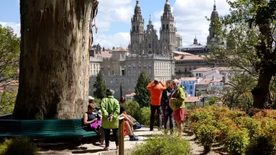
The Practical Confessions of an Urbanist Pilgrim
After 12 days of walking the Portuguese Camino, the importance of many urban planning and development debates—from balanced growth to banning cars—became abundantly clear.
A Sea of Infrastructure
An ex-pat American returns home to Milwaukee, and is overwhelmed by the extensive auto-oriented infrastructure needed to support the U.S. lifestyle, very different from his life in Almeria, Spain.

Alabama: Trump Terminates Settlements for Black Communities Harmed By Raw Sewage
Trump deemed the landmark civil rights agreement “illegal DEI and environmental justice policy.”

Planetizen Federal Action Tracker
A weekly monitor of how Trump’s orders and actions are impacting planners and planning in America.

The 120 Year Old Tiny Home Villages That Sheltered San Francisco’s Earthquake Refugees
More than a century ago, San Francisco mobilized to house thousands of residents displaced by the 1906 earthquake. Could their strategy offer a model for the present?

Ken Jennings Launches Transit Web Series
The Jeopardy champ wants you to ride public transit.

BLM To Rescind Public Lands Rule
The change will downgrade conservation, once again putting federal land at risk for mining and other extractive uses.

Indy Neighborhood Group Builds Temporary Multi-Use Path
Community members, aided in part by funding from the city, repurposed a vehicle lane to create a protected bike and pedestrian path for the summer season.
Urban Design for Planners 1: Software Tools
This six-course series explores essential urban design concepts using open source software and equips planners with the tools they need to participate fully in the urban design process.
Planning for Universal Design
Learn the tools for implementing Universal Design in planning regulations.
Clanton & Associates, Inc.
Jessamine County Fiscal Court
Institute for Housing and Urban Development Studies (IHS)
City of Grandview
Harvard GSD Executive Education
Toledo-Lucas County Plan Commissions
Salt Lake City
NYU Wagner Graduate School of Public Service