


For those that dream of traveling the length of the Golden State without getting behind the wheel of an automobile, a new map shows the interconnected system of trains and buses that can get you from San Diego to Eureka and in-between.
Aaron Bialick shares the new California Rail Map, a map of transit throughout the Golden State. Created by Alfred Twu and his team of cartographers, the map features “both intracity and regional rail lines as well as connecting buses, proving once and for all that it’s possible to get to almost anywhere in the state on public transit,” says Twu.
"The map ties together networks for Amtrak, BART, Muni, VTA, Caltrain, Altamont Commuter Express, Sacramento Regional Transit, San Diego North County Transit District (NCTD), San Diego Trolley, LA Metro, and Metrolink, as well as key bus and ferry connections."
And though the map includes more than 500 destinations reachable by train or connecting bus or ferry, you may want to time your trip with Google Maps before you plan to travel between Palm Springs and Yosemite.
FULL STORY: New California Transit Map Simplifies Car-Free Travel Across the State


Mapping Climate Impact at the Neighborhood Level
A consumption-based analysis illustrates the differences in average household emissions across census tracts.
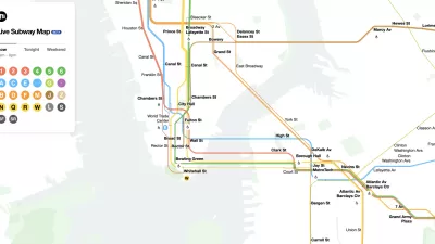
The New New York Subway Map Works in Real Time
There's a new chapter, and maybe an end, for the "Great Subway Map Debate."
Coming Soon: A New Transit Map for Philadelphia
Transit is getting a new look.

Trump Administration Could Effectively End Housing Voucher Program
Federal officials are eyeing major cuts to the Section 8 program that helps millions of low-income households pay rent.

Planetizen Federal Action Tracker
A weekly monitor of how Trump’s orders and actions are impacting planners and planning in America.

Ken Jennings Launches Transit Web Series
The Jeopardy champ wants you to ride public transit.

Opinion: Transit Agencies Must View Service Cuts as Last Resort
Reducing service could cripple transit systems by pushing more riders to consider car ownership, making future recovery even less certain.

‘Smart Surfaces’ Policy Guide Offers Advice for Building and Maintaining Urban Tree Canopies
Healthy, robust tree canopies can reduce the impacts of extreme heat and improve air quality.

New Jersey Lawsuit Targets Rent-Setting Algorithms
The state of New Jersey is taking legal action against landlords and companies that engage in what the state’s Attorney General alleges is illegal rent fixing.
Urban Design for Planners 1: Software Tools
This six-course series explores essential urban design concepts using open source software and equips planners with the tools they need to participate fully in the urban design process.
Planning for Universal Design
Learn the tools for implementing Universal Design in planning regulations.
Heyer Gruel & Associates PA
Ada County Highway District
Institute for Housing and Urban Development Studies (IHS)
City of Grandview
Harvard GSD Executive Education
Toledo-Lucas County Plan Commissions
Salt Lake City
NYU Wagner Graduate School of Public Service