


Technology
California to Cap Incomes Eligible for Electric Vehicle Rebates
A bill will attempt to bring some equity to the flagrantly inequitable rebate program that subsidizes purchases of Electric Vehicles. Additional subsidies would be directed to low income families. Rebates could also be used for car share and transit.
Ten Years of OpenStreetMap
Exactly how does a student take on an open data political stance and transform it into "the largest crowd-sourced mapping project on the internet"?
Fighting Wildfires with Big Data
WIFIRE, a real-time and data-driven simulation, prediction, and visualization technology, combines satellite and remote sensor data to forecast the potential spread of wildfires.
Mobile App Helps Battle Graffiti in Philadelphia
Philadelphia's Community Life Improvement Program is using Esri's Collector mobile app to empower their data collection in management. Prior to Collector, the anti-graffiti effort was driven by Excel.
The Mapping Tool that Helped Identify the Ebola Outbreak
An online mapping tool called HealthMap helped identify the recent outbreak of the Ebola virus in West Africa by pulling data from all over the big data spectrum. It can also tell provide insight into the health concerns in your area.
Researchers Pull Social Media Data to Track Migration
The limitations (and inaccuracies) of traditional data sources like the U.S. Census are well known, so researchers are looking social media to gather the data necessary to draw conclusions about societal movements.
Study uses Google Street View to Assess Gentrification
By assessing three different groups of indicators, researchers were able to tour thousands of blocks in Chicago through Google Street View and compare visual signs of reinvestment and renewal between 2007 and 2009.
Lyft Line, UberPool: Carpooling Features to Compete with Mass Transit
A new tier of service for Lyft launched today, allowing customers traveling in the same direction to share a ride. The new product follows a similar release earlier this week by Uber.
Floating Vertical Farms Could Deliver and Monitor Food Production in Dense Cities
Known for its density with nearly 20,000 people per square mile, Singapore is changing its food systems strategy to produce more food locally, and reduce food waste.
New Applications for 3D Printing: Sanitation and Shelter
Called by some the "third industrial revolution," what are some of the opportunities and costs of applying 3D printing to issues facing the developing world, and more importantly, emergency housing?
Unlocking the Biogas Potential in America's Farms
Thinking about "renewable power" often bring hydroelectric, wind, and solar to mind. The informed will recognize geothermal and biomass as major renewables. Biogas, the non-fossil natural gas, is not well known because few facilities capture it.
The New Era of 'Cities 3.0': Just Add Infrastructure
Any vision for a "City 3.0"—or an untethered, technology-enabled city—is dependent on next generation infrastructure for Internet, energy, water, and more.

How Self-Driving Cars Can (and Should) Improve Transit
Comments on the proceedings of the Automated Vehicles Symposium (San Francisco, July 14-18, 2014), where participants addressed the many transportation and land use implications of an automated future.
Out of the Frying Pan and into the Fire: Summer Temperatures in 2100
A new interactive map titled "1,001 Blistering Future Summers" displays predicted daytime summer heat temperatures for 1,001 cities in the United States for the year 2100.
Mapping Drone No-Fly Zones
While the FAA sorts out regulations for commercial drone flights in the United States, cities, states, and other groups have already restricted the flight of drones. Mapbox is working to compile a comprehensive map of prohibited air space.
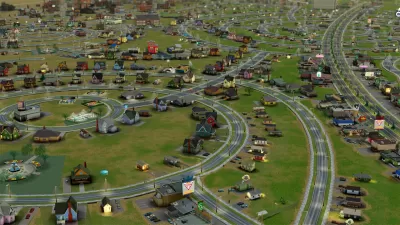
Gaming for Planners—More than SimCity
At the Serious Gaming workshop held in South Africa, game-maker Tygron showcased their game "The Climategame" and examined game play for lessons in how planners might improve their professional practice.

How Civic Engagement Platforms Can Bring Back the Expertise of Urban Planners
The increasing use of online civic engagement platforms offers a chance for planners to improve the planning process—that is, if they take full advantage of the opportunities presented by the new technology to showcase their expertise.
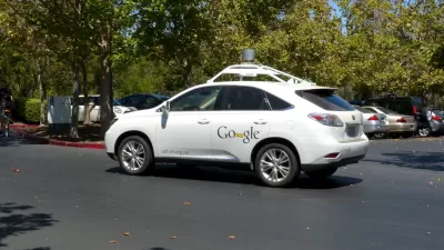
Concerns Raised about Sprawl, Public Safety Implications of Autonomous Vehicles
A pair of articles sounds separate warnings about what a future of autonomous vehicles will mean for law enforcement and fuel consumption. The warnings are far from the utopian ideal that many desire for the technology.
Speed Cameras: Working in Chicago; Needed in Philadelphia
In Chicago, speed cameras are proving effective at reducing speeds; in Philadelphia, a police commissioner is lobbying the state to allow the implementation of the cameras.
What's Missed When Taking the Scenic Route?
An app that plots the most beautiful route across cities made news earlier this month, but one commenter worries about how taking the more scenic route could make it harder to improve quality of life in the "less-than-scenic" sections of cities.
Urban Design for Planners 1: Software Tools
This six-course series explores essential urban design concepts using open source software and equips planners with the tools they need to participate fully in the urban design process.
Planning for Universal Design
Learn the tools for implementing Universal Design in planning regulations.
Ada County Highway District
Clanton & Associates, Inc.
Jessamine County Fiscal Court
Institute for Housing and Urban Development Studies (IHS)
City of Grandview
Harvard GSD Executive Education
Toledo-Lucas County Plan Commissions
Salt Lake City
NYU Wagner Graduate School of Public Service


