


Mapping
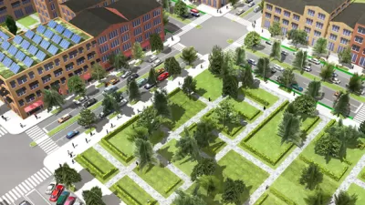
Build A 3D City Model Within Minutes
ESRI's CityEngine software enables 3D modeling of urban environments. The forthcoming version of the software will enable developers to use the 3D city modeling technology in their own software.
A Never-Ending Map Of Imaginary Cities
Artist spends decades creating an always-growing hand-drawn paper map of an imaginary place. Development is determined by drawing a random card from a custom deck of cards.
For Urban Poor, Enumeration Equals Inclusion
Marcus Tudehope offers 12 reasons why community-led counting and mapping of the urban poor can be an effective tool for putting "power and democracy" into their hands.
Mapping the City That Might Have Been
Driven by "the fantasy of the almost-reality," hobbyist mapmaker Andrew Lynch gives new life to plans that never happened with hypothetical maps of the city that almost was.
How Has 'Mapping' Changed How We Communicate Ideas About Buildings and Landscapes?
Cartographic Grounds, a recent exhibition at the Harvard Graduate School of Design — now online at Places — seeks to "reconcile the precision and instrumentality of the plan with the geographic and territorial scope of the map."
Mapping Chicago's Growing Cornucopia of Urban Gardens
In Chicago, like in many cities, local food production comes in many forms, from small backyard crops to community gardens. Researchers are now using Google Earth to paint a more accurate picture of food production at different scales.
Move Over iPad, the Digital Globe Has Arrived
Can dynamic digital globes compete with flatter technologies like today’s iPad? Mark Vanhoenacker explores some of the possibilities these modern spheres may bring to places of work, study and play.
Six Magnificent Maps of 2012
The "best of 2012" lists are just starting to spread and, already, one of the most unique collections we've come across is Caitlin Dempsey's look at the year's most interesting maps. You don't have to be a cartographer to enjoy these visualizations.
Map Apps Move Indoors
A time when your mobile phone can help you navigate the homogenous corridors of an indoor mall as easily as the route that got you there is, seemingly, not far off, as Seoul unveils an app that can navigate the city both above and below street level.
Who Defines New York's Nabes? For Starters Look to These Amateur Mapmakers
In New York, neighborhood boundaries are big business. Just ask any real estate agent who's tried to pass off a Gowanus apartment as being in Park Slope. Since the city does not officially define boundaries, amateurs are filling the void.
Mapping Settlements to Shift the Balance of Power
David Kilcullen creates maps to empower disenfranchised people in developing countries around the world. By combining social science and technology his firm solves tough problems in "frontier environments," reports David Holmes.
Map Making Before Computers: How'd They Do It?
Ever wonder how maps were made in the decades before vector-based graphics software like Adobe Illustrator were invented? The Atlantic has posted a film from the 1940's that documents the process of "Modern Map Making."
Bringing Dead Space Back to Life in Brooklyn
Sarah Goodyear discovers a project to help Brooklynites reclaim land owned by the city, but long since abandoned, and building neighborhood bonds in the process.
NASA Map of Forests Provides Lessons for Information Design
Tim Maly analyses a stunning high-resolution map of America’s forests for its lessons on the subtle choices that go into good visual information design for multiple audiences.
What Can We Do With Crowdsourced Maps?
Shriya Malhotra explores the potential for participatory mapping to manage the complexities of cities in the 21st century.
Moscow Cyclists Doing it for Themselves
Jennifer Hattam profiles a DIY project of artist Anton Polsky, who set out to create a better bike map for the city of Moscow.
CicLAvia Tour Integrates Crowdsourcing
As cyclists toured Watts and other parts of South Los Angeles, they were invited to share photographs and record places of interest along the way.
Getting Around Underground Could be Easier
Part of this week's Urban Design Week in New York City, design duo Original Champions of Design present three solutions to a weak wayfinding system currently in place in the city's subways.
NYC Subway Gets Touchscreen That Tells You Where Delays Are
Cisco has sponsored a number of "Travel Stations" to be tested in a handful of subway stops. Dan Nosowitz went down to Bowling Green to try one out.
Putting Alternative Fuel Stations on the Map
Yesterday, the U.S. Department of Energy released an interactive map displaying thousands of alternative fuel stations around the nation.
Urban Design for Planners 1: Software Tools
This six-course series explores essential urban design concepts using open source software and equips planners with the tools they need to participate fully in the urban design process.
Planning for Universal Design
Learn the tools for implementing Universal Design in planning regulations.
Heyer Gruel & Associates PA
Ada County Highway District
Institute for Housing and Urban Development Studies (IHS)
City of Grandview
Harvard GSD Executive Education
Toledo-Lucas County Plan Commissions
Salt Lake City
NYU Wagner Graduate School of Public Service


