


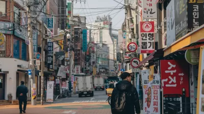
A time when your mobile phone can help you navigate the homogenous corridors of an indoor mall as easily as the route that got you there is, seemingly, not far off, as Seoul unveils an app that can navigate the city both above and below street level.
Elizabeth Woyke examines the soon to be released free mobile application, called Fing, that, "could set a new standard for city navigation guides around the world."
According to Woyke, "Street-level navigation taps the phone's GPS like a typical mapping
app." But it's when you leave the gaze of GPS tracking satellites that the innovation begins: "in places where GPS doesn't work, such as underground and deep
inside shopping malls, Fing switches to Wi-Fi-based indoor positioning
to track users' locations and provide directions."
"By making malls and underground markets easily navigable, Fing's
creators hope to encourage shopping and socializing. The app is backed
by the Korea Trade Network (KTNET), a subsidiary of Korea's
international trade association."
But not all of its potential uses are tied to extracting more dollars from your wallet. Woyke notes that, "Another major use of the app could end up being emergency aid. A
one-click feature in Fing will send a text message to the nearest police
or fire department. The message will include a request for help and the
coordinates of the user's location for expedited rescue."
FULL STORY: Citywide Indoor Navigation Is Closer Than You Think


Seoul’s Urban Parks Blossom with Books
The Reading in Seoul Garden event invited residents to enjoy free reading and relaxation activities, including digital and live programs, in scenic parks, fostering a sense of community amid the city’s autumn landscapes.
The Basement Apartments of Seoul’s Urban Poor
The lives of Seoul's poorest residents in squalid below-ground housing are brought out of the shadows in the film "Parasite."
'No Driving Day' in Seoul Means Free Transit Rides
South Korea has made public transit a key part of its approach to cleaning the air.

Study: Maui’s Plan to Convert Vacation Rentals to Long-Term Housing Could Cause Nearly $1 Billion Economic Loss
The plan would reduce visitor accommodation by 25,% resulting in 1,900 jobs lost.

North Texas Transit Leaders Tout Benefits of TOD for Growing Region
At a summit focused on transit-oriented development, policymakers discussed how North Texas’ expanded light rail system can serve as a tool for economic growth.

Why Should We Subsidize Public Transportation?
Many public transit agencies face financial stress due to rising costs, declining fare revenue, and declining subsidies. Transit advocates must provide a strong business case for increasing public transit funding.

How Community Science Connects People, Parks, and Biodiversity
Community science engages people of all backgrounds in documenting local biodiversity, strengthening connections to nature, and contributing to global efforts like the City Nature Challenge to build a more inclusive and resilient future.

Alabama: Trump Terminates Settlements for Black Communities Harmed By Raw Sewage
Trump deemed the landmark civil rights agreement “illegal DEI and environmental justice policy.”

Dear Tesla Driver: “It’s not You, It’s Him.”
Amidst a booming bumper sticker industry, one writer offers solace to those asking, “Does this car make me look fascist?”
Urban Design for Planners 1: Software Tools
This six-course series explores essential urban design concepts using open source software and equips planners with the tools they need to participate fully in the urban design process.
Planning for Universal Design
Learn the tools for implementing Universal Design in planning regulations.
City of Santa Clarita
Ascent Environmental
Institute for Housing and Urban Development Studies (IHS)
City of Grandview
Harvard GSD Executive Education
Toledo-Lucas County Plan Commissions
Salt Lake City
NYU Wagner Graduate School of Public Service