


Apps
The Online Tool for Comparing Bus Rapid Transit Data
A tool from EMRARQ Brasil allows users to compile and compare data on the use and growth of bus rapid transit around the world, including in the United States, where 18 cities now use BRT or bus priority corridors.
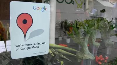
How Google Maps Gets the 'Ground Truth' for Street View
A peak under the hood at "Ground Truth"—the operation behind Google Street View.
Six Helpful Apps for Urban Designers
Leslie Clagett shares a list of apps for urban designers (helpful to project managers, too) "to streamline design problems, decision making, and materials selection."
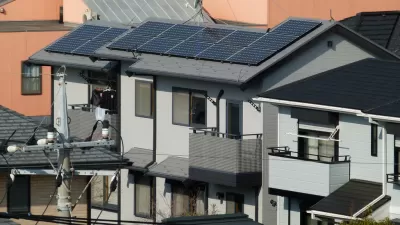
Mapping the Solar Potential of Every Roof
A new app out of MIT provides property owners with detailed information about the solar potential of their roofs. The app is currently at work in five cities.
Mobile Apps to Inspire Walking
Bill Lindeke examines a few examples of mobile technology that encourage citizens to ditch their cars and walk. Could these technologies inspire the cultural side of the equation needed for widespread adoption of walkability?
Can the 'Sharing Economy Advisory Network' Help Cities and the New Economy Get Along?
The National League of Cities has created the Sharing Economy Advisory Network to develop best practices for cities in developing regulations while also allowing sharing economy businesses to expand and operate.
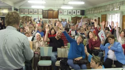
How Civic Engagement Platforms Can Bring Back the Expertise of Urban Planners
The increasing use of online civic engagement platforms offers a chance for planners to improve the planning process—that is, if they take full advantage of the opportunities presented by the new technology to showcase their expertise.
What's Missed When Taking the Scenic Route?
An app that plots the most beautiful route across cities made news earlier this month, but one commenter worries about how taking the more scenic route could make it harder to improve quality of life in the "less-than-scenic" sections of cities.
New Zoning Query App Answers the Question: 'Where Can I Open My Business?'
A new app called ZoningCheck provides users a responsive query function. In addition to the obvious layer of bureaucratic interface saved by the process, the app also makes a compelling case for the benefits of open municipal codes.
An App that Calculates the Most Beautiful Route
New in flaneur-enabling technology: a team of intrepid aesthetes in Barcelona is working on a new app that would advance GPS mapping tools by providing the most beautiful route to a destination, rather than the shortest or least congested route.
App Maps the Unbuilt Potential of the New York City Skyline
The "Accidental Skyline" project puts a powerful visualization tool in the hands of citizens curious to know more about the possible development enabled by the land use regulations of New York City.
Location as Currency: Mapping Apps Will Optimize Indoor Navigation
"Location is the new cookie," says Simon Thompson of Esri, referencing the software in a browser that tracks the websites people visit. Meet the new apps making it happen.
For Sale: Data on 90 Million Bike Rides and 20 Million Runs
The same week that the New York Police Department released a boat load of data about traffic collisions comes news that exercise app Strava will sell its data on the how, where, and when bikers and runners use streets.
New App Would Auction Public Parking Spaces
The MonkeyParking app works similarly to sharing economy stars Airbnb or Uber, except for sale is an inside line on parking spaces. That means that private users would be auctioning the use of public space. That can't be legal, can it?

Trends to Watch in Planetizen’s Top Posts
We post a lot of articles here at Planetizen, and the traffic created by you, our audience, provides valuable feedback about the ideas and places of interest to the planning and urbanism community.
Seven Apps to Improve Quality of Life in Cities
It’s no secret that more and more people are using smart phones to get the most out of their urban experiences—at home or while traveling. Guardian Cities lists some of the best urban apps and launches a contest to find the best apps worldwide.
A Low-Cost Way to Improve Transit Service in Every City
The developers of a transit-tracking app have some for exciting news for public officials: There's a way to improve transit rider satisfaction without reducing fares, buying new vehicles or expanding service. Just give your users more information.
Looking for Your Ideal Community? Try This New Census App
Dwellr is a new app from the Census Bureau that matches the top 25 U.S. cities and towns to your lifestyle preferences. And unlike other recent federal technology rollouts, this one seems to work pretty well.
Civic Tech and Mobile Engagement 2.0
Community engagement efforts increasingly look to harness mobile devices and mobile applications to access, inform, and empower the public. However the mobile market is evolving at a fast pace, which complicates our understanding of what works best.
Pilot Program Will Monitor Car Computers to Fix New York Streets
A pilot program operated by New York's DOT will gather data from 500 city motorists' vehicles in order to find problematic city streets and help drivers reduce their gas use and increase their safety.
Urban Design for Planners 1: Software Tools
This six-course series explores essential urban design concepts using open source software and equips planners with the tools they need to participate fully in the urban design process.
Planning for Universal Design
Learn the tools for implementing Universal Design in planning regulations.
Caltrans
Smith Gee Studio
Institute for Housing and Urban Development Studies (IHS)
City of Grandview
Harvard GSD Executive Education
Toledo-Lucas County Plan Commissions
Salt Lake City
NYU Wagner Graduate School of Public Service


