


"Location is the new cookie," says Simon Thompson of Esri, referencing the software in a browser that tracks the websites people visit. Meet the new apps making it happen.
With a new app called Indoor Atlas, "anyone can use a smartphone’s compass to navigate the interior," writes Quentin Hardy. The new app will bring about the probably overdue convergence of location technology and crowdsourcing in indoor settings. In fact, says Hardy, "our indoor lives will be mapped much as street addresses are today, challenging both conventional business practices and human intimacy."
"A Finnish company called IndoorAtlas has figured out that all buildings have a unique magnetic 'fingerprint' — and has solved how to use that to determine locations inside a structure to within six feet. That is enough to take a consumer to a product in a crowded supermarket, or figure out the location of, say, a half-dozen workers in a building full of them. It’s also much better than cell phone towers can do."
Here's how a savvy marketer could use the app: "IndoorAtlas has enjoyed some success selling the service to stores in Finland. In at least one case, shoppers can load their week’s shopping into their phones, and get interior directions about where every product is located, and how to efficiently walk through the store to get everything."
The article compares the technology to that of OpenStreetMap—a favorite among planners—and predicts an eventual integration of interior and exterior location technologies. "Maps of building interiors, combining the visual logs of OpenSteetMap and the magnetic fingerprints, seem like something that could be easily cobbled together. At that point, a person could get directions that extend all the way to how to walk right to a person’s cubicle."
Hardy mentions two other technologies that might help lead the revolution: Urban Engines and Euclid Analytics.
FULL STORY: Mapping Our Interiors

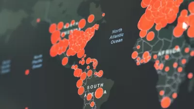
Visualizing the Coronavirus Pandemic
Mapping of the crisis is producing a fascinating and important trove of cartographic records.

An App for California State Parks
California's Department of Parks and Recreation is getting into the app business. It is hoped that CaliParks will help improve access to the state's parks for young people and minorities.
CityMap Expands to the Global Stage with its Social Mapping System
The owners of CityMap call it one of the most social and most monetizable maps in the world. With a new expansion plan announced this week, the app—which launched in 2012 with a map of every shop in New York City—is going global.

Alabama: Trump Terminates Settlements for Black Communities Harmed By Raw Sewage
Trump deemed the landmark civil rights agreement “illegal DEI and environmental justice policy.”

Planetizen Federal Action Tracker
A weekly monitor of how Trump’s orders and actions are impacting planners and planning in America.

The 120 Year Old Tiny Home Villages That Sheltered San Francisco’s Earthquake Refugees
More than a century ago, San Francisco mobilized to house thousands of residents displaced by the 1906 earthquake. Could their strategy offer a model for the present?

In Both Crashes and Crime, Public Transportation is Far Safer than Driving
Contrary to popular assumptions, public transportation has far lower crash and crime rates than automobile travel. For safer communities, improve and encourage transit travel.

Report: Zoning Reforms Should Complement Nashville’s Ambitious Transit Plan
Without reform, restrictive zoning codes will limit the impact of the city’s planned transit expansion and could exclude some of the residents who depend on transit the most.

Judge Orders Release of Frozen IRA, IIJA Funding
The decision is a victory for environmental groups who charged that freezing funds for critical infrastructure and disaster response programs caused “real and irreparable harm” to communities.
Urban Design for Planners 1: Software Tools
This six-course series explores essential urban design concepts using open source software and equips planners with the tools they need to participate fully in the urban design process.
Planning for Universal Design
Learn the tools for implementing Universal Design in planning regulations.
Clanton & Associates, Inc.
Jessamine County Fiscal Court
Institute for Housing and Urban Development Studies (IHS)
City of Grandview
Harvard GSD Executive Education
Toledo-Lucas County Plan Commissions
Salt Lake City
NYU Wagner Graduate School of Public Service