


Lidar

Two Underwhelming Elon Musk Projects on Display at CES
Demonstrations at the Consumer Electronics Show in Las Vegas highlight the failures of Tesla's autonomous vehicles and the Boring Company's tunnels.
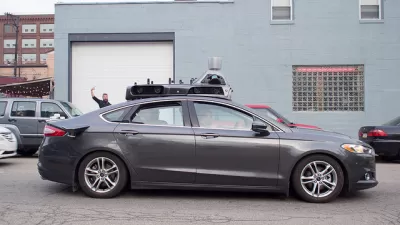
Scrutiny Turns Toward Uber After First Pedestrian Death by Autonomous Vehicle
It's not just the autonomous vehicle technology, but also the company that operated the self-driving SUV receiving scrutiny after the death of Elaine Herzberg in Tempe, Az. on March 18.

Failure of Automated Driving Technology Blamed for First Pedestrian Fatality
Experts who watched the videos taken by onboard cameras equipped in the Volvo SUV that hit Elaine Herzberg determined that Uber's automated driving system failed to perform adequately. The crash points to a need for regulations.

Take a LiDAR Tour of Dublin
The potential of Light Detection and Ranging (LiDAR) data to redefine mapping and modeling will be on display in the city of Dublin, Ireland, after NYU researchers released the largest ever LiDAR data set.
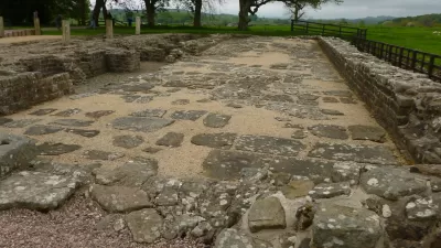
Uncovering the Roman Roads Cutting Across England
An amateur archaeologist has taken modern technology to dig into history, unearthing the roads built by Romans over 2,000 years ago in England.
Urban Forestry Gets State-of-the-Art Assistance with LiDAR Technology
Advanced remote sensing technologies are providing cities and planners across the United States with new tools to assess urban tree canopy and develop more effective urban reforestation efforts.

Stunning Discovery Upends Our Understanding of Pre-Industrial Urbanism
The results of a survey conducted last year of the forests of Cambodia, but just published this month, has found a complex landscape of "low-density urban sprawl" connected to Angkor Wat, upending our understanding of pre-industrial urbanism.
Did a Promising Technology Help Find a Lost City of Gold?
Conor Myhrvold writes about the application of remote sensing technology to the search for ancient South American cities reclaimed by time and nature.
Eye in the Sky Maps Ancient Maya
Advanced laser imaging technology known as lidar has proven to be an effective and fast way to map ancient Mayan villages.
Mapping for Solar Power - With Lasers
Part of Mayor Bloomberg's PlaNYC campaign involves taking detailed scans of the city from the sky to determine the suitability if sites for solar power.
Urban Design for Planners 1: Software Tools
This six-course series explores essential urban design concepts using open source software and equips planners with the tools they need to participate fully in the urban design process.
Planning for Universal Design
Learn the tools for implementing Universal Design in planning regulations.
Caltrans
Smith Gee Studio
Institute for Housing and Urban Development Studies (IHS)
City of Grandview
Harvard GSD Executive Education
Toledo-Lucas County Plan Commissions
Salt Lake City
NYU Wagner Graduate School of Public Service


