


Part of Mayor Bloomberg's PlaNYC campaign involves taking detailed scans of the city from the sky to determine the suitability if sites for solar power.
The scan is taken using Lidar laser technology from a small plane sweeping over the city. The scan is intended to detect the presence of existing wetlands and the number of roofs suitable for solar power. The final result? A "solar map" that developers and building owners can consult to determine whether solar panels make sense for them.
Mireya Navarro writes, "Cities like San Francisco have already developed solar maps, and the new Lidar technology is increasingly being adopted by coastal regions around the nation, FEMA officials said. The laser system captures images of surface terrain and structures by shooting out laser pulses from an aircraft and measuring the time it take the pulses to bounce back, producing representations of what it hits."
FULL STORY: With Flyovers, a Solar Map of New York

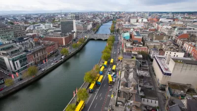
Take a LiDAR Tour of Dublin
The potential of Light Detection and Ranging (LiDAR) data to redefine mapping and modeling will be on display in the city of Dublin, Ireland, after NYU researchers released the largest ever LiDAR data set.
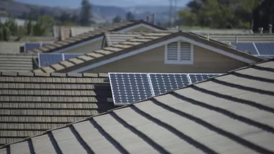
Google Debuts Rooftop Solar Mapping Tool
Currently in its early stages, Project Sunroof tracks how much sun every roof receives. Then it estimates the costs and savings if rooftop solar were installed. Right now, the tool only covers the Bay Area, Fresno, and Boston.
Eye in the Sky Maps Ancient Maya
Advanced laser imaging technology known as lidar has proven to be an effective and fast way to map ancient Mayan villages.

Alabama: Trump Terminates Settlements for Black Communities Harmed By Raw Sewage
Trump deemed the landmark civil rights agreement “illegal DEI and environmental justice policy.”

Study: Maui’s Plan to Convert Vacation Rentals to Long-Term Housing Could Cause Nearly $1 Billion Economic Loss
The plan would reduce visitor accommodation by 25% resulting in 1,900 jobs lost.

Planetizen Federal Action Tracker
A weekly monitor of how Trump’s orders and actions are impacting planners and planning in America.

Wind Energy on the Rise Despite Federal Policy Reversal
The Trump administration is revoking federal support for renewable energy, but demand for new projects continues unabated.

Passengers Flock to Caltrain After Electrification
The new electric trains are running faster and more reliably, leading to strong ridership growth on the Bay Area rail system.

Texas Churches Rally Behind ‘Yes in God’s Back Yard’ Legislation
Religious leaders want the state to reduce zoning regulations to streamline leasing church-owned land to housing developers.
Urban Design for Planners 1: Software Tools
This six-course series explores essential urban design concepts using open source software and equips planners with the tools they need to participate fully in the urban design process.
Planning for Universal Design
Learn the tools for implementing Universal Design in planning regulations.
Caltrans
Smith Gee Studio
Institute for Housing and Urban Development Studies (IHS)
City of Grandview
Harvard GSD Executive Education
Toledo-Lucas County Plan Commissions
Salt Lake City
NYU Wagner Graduate School of Public Service