


The potential of Light Detection and Ranging (LiDAR) data to redefine mapping and modeling will be on display in the city of Dublin, Ireland, after NYU researchers released the largest ever LiDAR data set.

Darrell Etherington reports: "New York University has made available the densest public LiDAR data set ever collected, via its Center for Urban Science and Progress."
"The laser scanned data, collected using aerial LiDAR instruments, is about 30 times as dense as a typical data set at a resolution of around 300 points per square meter, and covers a 1.5km square region of Dublin’s city center," adds Etherington. The researchers hope to undertake a similar survey of New York City soon.
The article includes some commentary of the importance of open access to data of this scope and quality. This data is available on NYU's Spatial Data Repository.
FULL STORY: NYU releases the densest LiDAR dataset ever to help urban development


Dublin Will Ban Through Traffic Downtown
A vast majority of residents support a plan to limit vehicular traffic through the city’s center.
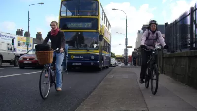
Dublin's Grand Biking Vision That Never Came to Fruition
Dublin’s future as a leading cycling city was once bright, but many plans have stalled or fallen by the wayside.

Advice for New York's Bus System Overhaul
It's time for a fresh start, says a bus system redesign expert.

Trump Administration Could Effectively End Housing Voucher Program
Federal officials are eyeing major cuts to the Section 8 program that helps millions of low-income households pay rent.

Planetizen Federal Action Tracker
A weekly monitor of how Trump’s orders and actions are impacting planners and planning in America.

Ken Jennings Launches Transit Web Series
The Jeopardy champ wants you to ride public transit.

Crime Continues to Drop on Philly, San Francisco Transit Systems
SEPTA and BART both saw significant declines in violent crime in the first quarter of 2025.

How South LA Green Spaces Power Community Health and Hope
Green spaces like South L.A. Wetlands Park are helping South Los Angeles residents promote healthy lifestyles, build community, and advocate for improvements that reflect local needs in historically underserved neighborhoods.

Sacramento Plans ‘Quick-Build’ Road Safety Projects
The city wants to accelerate small-scale safety improvements that use low-cost equipment to make an impact at dangerous intersections.
Urban Design for Planners 1: Software Tools
This six-course series explores essential urban design concepts using open source software and equips planners with the tools they need to participate fully in the urban design process.
Planning for Universal Design
Learn the tools for implementing Universal Design in planning regulations.
Heyer Gruel & Associates PA
Ada County Highway District
Institute for Housing and Urban Development Studies (IHS)
City of Grandview
Harvard GSD Executive Education
Toledo-Lucas County Plan Commissions
Salt Lake City
NYU Wagner Graduate School of Public Service