


Data
On the Limitations—and Unanswered Questions—of Housing Research
Limitations of data collection mean many questions about housing consumption simply cannot be answered.
New App from the U.S. EPA Maps Environmental Justice
A publicly available web tool allows access to maps that overlay environmental impacts and the populations they impact (or the populations that manage to avoid such impacts, for that matter).

How Cities Are Regulating the Sharing Economy
Compiled from interviews conducted with city officials, this National League of Cities report gives us a regulator's-eye-view of the sharing economy. Among the topics discussed are equity, taxation, and data transparency.
Website Opens Bay Area Transportation Data to the Masses
The Metropolitan Transportation Commission—the Bay Area's regional transportation planning agency—recently did fans of data and mapping a huge favor and launched a website called Vital Signs.
Study Shows How Useful Twitter Data Can Be for Planners
The atlantalarry blog shares news of a study in the Engineering Applications of Artificial Intelligence journal that used gelocalized tweets to map out nightlife areas in Madrid, London, and Manhattan.
The Online Tool for Comparing Bus Rapid Transit Data
A tool from EMRARQ Brasil allows users to compile and compare data on the use and growth of bus rapid transit around the world, including in the United States, where 18 cities now use BRT or bus priority corridors.
'Self-Sufficiency Standard' Reveals Distressing Levels of Poverty
Most policies regarding poverty are driven by obsolete metrics. Another model, which measures the very basic needs for survival, reveals deep poverty in New York City.
Los Angeles Lacking Data to Support Bike Infrastructure Investments
Los Angeles has added hundreds of miles of bike routes in recent years, but the local paper of record identifies a lack of data as contributing to ongoing discord from drivers who feel like they're being pinched by bike lanes.

What's Good about Being an Urban Planner?
For urban planners, it’s easy to focus on the negatives of the job. Los Angeles County Planner Clement Lau reminds us of some of the positive trends in planning, especially in Los Angeles.
Looking at 'Data-Driven Government' from Inside City Hall
"Metrics" has become a buzzword in local government, but how do municipalities actually harness data to improve city services, operations, and accountability?
Millennials and Gen Xers Commuting Less by Car
Following up on earlier reports about the latest commuting data from the U.S. Census 2013 American Community Survey, Joseph Kane and Adie Tomer find different trends in commute choice between age groups.
Two Narratives Derived from New Commute Data
When it comes to making sense of the American Community Survey's data on commute times, it's all about how you frame the data.
Census Releases Data on County-to-County Migration
A new data set released this week by the U.S. Census is helpful for determining patterns of migration during the recession-troubled years of 2008-2012.

What Computer Scientists Can Teach Planners About Design
Architect Dave Hampton reviews the 2nd annual Urban Sciences Research Coordination Network workshop held June 11 in Chicago.
Special Delivery: Housing Data Provided by the United States Postal Service
If you're looking for more data on housing in the United States, a dataset produced by the United States Postal Service has many advantages.
Tracking Chicago’s Potholes
A new animated map presents the reported cases of potholes in Chicago since November—the maps colorful and provides insights into how the city, and our relationship to it, can change with time.
Friday Eye Candy: Mapping Urban Exercise Patterns
An enterprising blogger has produced a slew of urban maps with an overlay of publicly available data on exercise routes. In addition to being fetching, the patterns revealed show how runners make use of the public realm.
Using Data to Design St. Louis' Redevelopment Efforts
A HUD funded project has provided the city of St. Louis with a fine-grained map of residential real estate conditions across the city. Officials are hopeful the data will better guide the distribution of precious community development dollars.
What the Data Says About Life in the City
Cities can be undersold or oversold in equal measure, but they never fail to present a shortage of data. With its #citydata series, This Big City explores the sometimes surprising facts about cities that emerge from the din of urban life.
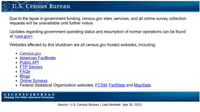
Where to Find Federal Data During the Shutdown
When the federal government shut down last week it took many agency websites along with it, depriving planners around the U.S. of resources they use daily. The blog Data Insights has put together a list of alternative sources for federal data.
Urban Design for Planners 1: Software Tools
This six-course series explores essential urban design concepts using open source software and equips planners with the tools they need to participate fully in the urban design process.
Planning for Universal Design
Learn the tools for implementing Universal Design in planning regulations.
City of Albany
UCLA Lewis Center for Regional Policy Studies
Mpact (formerly Rail~Volution)
Chaddick Institute at DePaul University
City of Piedmont, CA
Great Falls Development Authority, Inc.
HUDs Office of Policy Development and Research


