


An enterprising blogger has produced a slew of urban maps with an overlay of publicly available data on exercise routes. In addition to being fetching, the patterns revealed show how runners make use of the public realm.
Dr. Nathan Yau, PhD, who runs the FlowingDate blog, has produced a series of maps for cities both large and small around the country, using the app RunKeeper to source data. The app Strava, for bikers, according to Dr. Yau, would also work in the same way and has been used to good effect before (although on an individual basis).
As Dr. Yau aptly points out: “[the visualization] can be useful to the data collectors to plan future workouts or even city planners who make sure citizens have proper bike lanes and running paths.”
And here’s Dr. Yau’s initial takeaway about what the maps say about how runners make use of the public realm: “If there's one quick (and expected) takeaway, it's that people like to run by the water and in parks, probably to get away from cars and the scenery. In the smaller inland cities, there seem to be a few high-traffic roads with less running elsewhere.”
FULL STORY: Where people run

Mapped: Every Building in the United States
Using data from Microsoft, the New York Times has published an online map showing the placement of every building in the country, in a simple black and white format.
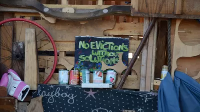
California Evictions Much Faster and More Frequent Than Previously Thought
About 500,000 tenants face eviction every year—triple previous estimates. And over a million may be involuntary displaced despite never making it to court.
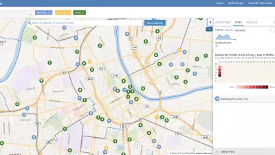
Presenting Municipal Data in an Interactive Map, Nashville Style
The city of Nashville launched the NashView interactive data map earlier this month.

Alabama: Trump Terminates Settlements for Black Communities Harmed By Raw Sewage
Trump deemed the landmark civil rights agreement “illegal DEI and environmental justice policy.”

Planetizen Federal Action Tracker
A weekly monitor of how Trump’s orders and actions are impacting planners and planning in America.

The 120 Year Old Tiny Home Villages That Sheltered San Francisco’s Earthquake Refugees
More than a century ago, San Francisco mobilized to house thousands of residents displaced by the 1906 earthquake. Could their strategy offer a model for the present?

Ken Jennings Launches Transit Web Series
The Jeopardy champ wants you to ride public transit.

BLM To Rescind Public Lands Rule
The change will downgrade conservation, once again putting federal land at risk for mining and other extractive uses.

Indy Neighborhood Group Builds Temporary Multi-Use Path
Community members, aided in part by funding from the city, repurposed a vehicle lane to create a protected bike and pedestrian path for the summer season.
Urban Design for Planners 1: Software Tools
This six-course series explores essential urban design concepts using open source software and equips planners with the tools they need to participate fully in the urban design process.
Planning for Universal Design
Learn the tools for implementing Universal Design in planning regulations.
Clanton & Associates, Inc.
Jessamine County Fiscal Court
Institute for Housing and Urban Development Studies (IHS)
City of Grandview
Harvard GSD Executive Education
Toledo-Lucas County Plan Commissions
Salt Lake City
NYU Wagner Graduate School of Public Service