


Artist-scientist Stephen Von Worley is taking on a new project— mapping the world's city streets based on a complex set of algorithms and psychedelic colors.
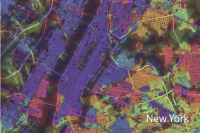
As discussed on Urbanful by John Benjamin, Stephen Von Worley's newest project is called Crayon the Grids. It uses a variety of colors like hot pink, lime green, orange, and deep purple in correlation "to the angle of each street and the city’s cardinal points, with visual weight being added to avenues that serve as anchors to each grid. Different colors, in other words, mean different orientations; different thickness signifies the importance of the road as a thoroughfare."
While grid-oriented cities such as New York, Chicago, and Los Angeles boast maps that are predominantly one color with other splotches mixed in, older radial cities like Paris, Berlin, and London are awash with intersecting colors and lines.
The maps provide insight on the cohesion of city streets, and the expansion of the city over time. Worsley has created maps for a variety of different cities, which can be found here.
FULL STORY: Immerse yourself in the technicolor maps of “Crayon the Grids”


Friday Eye Candy: A Sorely-Needed Map of New York City Neighborhoods
Neighborhoods don't get the same official boundaries as cities, counties, states, and countries. So how do we know where one neighborhood ends and another begins?
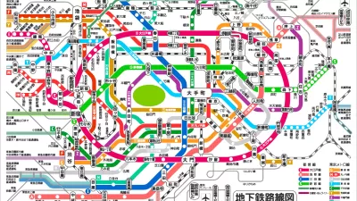
Friday Eye Candy: The World's Subway Systems, If You Could See Them From Above
Have you ever flown over a city and imagined all the subway lines running beneath the surface?
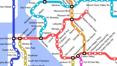
Friday Funny: Imagining Taco Bell-Oriented Rail Transit
A Reddit user created a transit map of the San Francisco Bay Area that connects Taco Bell locations, which, unlike rail public transit, have reached every corner of the region.

Trump Administration Could Effectively End Housing Voucher Program
Federal officials are eyeing major cuts to the Section 8 program that helps millions of low-income households pay rent.

Planetizen Federal Action Tracker
A weekly monitor of how Trump’s orders and actions are impacting planners and planning in America.

Ken Jennings Launches Transit Web Series
The Jeopardy champ wants you to ride public transit.

Philadelphia Is Expanding its Network of Roundabouts
Roundabouts are widely shown to decrease traffic speed, reduce congestion, and improve efficiency.

Why Bike Lanes Are Good: An Explainer for the US Transportation Secretary
Sean Duffy says there’s no evidence that bike lanes have benefits. Streetsblog — and federal agencies’ own data — beg to differ.

California Invests Additional $5M in Electric School Buses
The state wants to electrify all of its school bus fleets by 2035.
Urban Design for Planners 1: Software Tools
This six-course series explores essential urban design concepts using open source software and equips planners with the tools they need to participate fully in the urban design process.
Planning for Universal Design
Learn the tools for implementing Universal Design in planning regulations.
Ada County Highway District
Clanton & Associates, Inc.
Jessamine County Fiscal Court
Institute for Housing and Urban Development Studies (IHS)
City of Grandview
Harvard GSD Executive Education
Toledo-Lucas County Plan Commissions
Salt Lake City
NYU Wagner Graduate School of Public Service