


A Reddit user created a transit map of the San Francisco Bay Area that connects Taco Bell locations, which, unlike rail public transit, have reached every corner of the region.
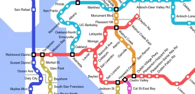
Reddit user u/Epicapabilities, actually 16-year-old Jeff McGough, a high school student from Minnesota, created a Taco Bell-connected fantasy map of rail transit in the San Francisco Bay Area and environs that won attention recently. The map spreads from Dixon to Rio Vista to Cloverdale to Manteca to Monterey, with all the Tracys, Gilroys, Redwood Citys, Santa Rosas, and Cordelias between included.
I grew up near the Clayton Rd station imagined on the map and frequented the Taco Bell in question before I knew any better, but I don't see an advertisement for bad fast food in this map. I see the fantasy transit map of the region I grew up in if cars had somehow skipped the 20th century. Sure, there are too many transfers on this map. I'm sure people in Vallejo and Benicia would love a one-seat ride into The City.
Still. Imagine such a world. Then again, it's hard to imagine Taco Bell being so ubiquitous in a world without cars. Is that a win-win?
McGough also created a similar map for Whataburger locations in Austin, Target in the Twin Cities, and Taco Bells in cities all over the country. Taco Bell picked up McGough's work for its blog.
FULL STORY: If Taco Bell connected their locations with a rail system


Friday Eye Candy: Mapping the Nation's Internet Trolls
Finally, we know where Internet trolls come from—no, not the basements of parents' houses.
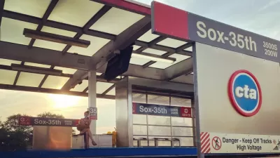
$2 Billion Federal Grant for Red Line Extension Project to Chicago’s South Side
A plan to extend the Chicago Transit Authority (CTA) Red Line 5.6 miles to the south won a $2 billion grant from the federal government.
Virginia Passenger Rail Sets Ridership Records, Seeks More Wins
Virginia’s commitment to intercity rail is paying off in record ridership numbers, but more work will be necessary to achieve the state’s ambitions for passenger rail.

Trump Administration Could Effectively End Housing Voucher Program
Federal officials are eyeing major cuts to the Section 8 program that helps millions of low-income households pay rent.

Planetizen Federal Action Tracker
A weekly monitor of how Trump’s orders and actions are impacting planners and planning in America.

Ken Jennings Launches Transit Web Series
The Jeopardy champ wants you to ride public transit.

Opinion: Transit Agencies Must View Service Cuts as Last Resort
Reducing service could cripple transit systems by pushing more riders to consider car ownership, making future recovery even less certain.

‘Smart Surfaces’ Policy Guide Offers Advice for Building and Maintaining Urban Tree Canopies
Healthy, robust tree canopies can reduce the impacts of extreme heat and improve air quality.

New Jersey Lawsuit Targets Rent-Setting Algorithms
The state of New Jersey is taking legal action against landlords and companies that engage in what the state’s Attorney General alleges is illegal rent fixing.
Urban Design for Planners 1: Software Tools
This six-course series explores essential urban design concepts using open source software and equips planners with the tools they need to participate fully in the urban design process.
Planning for Universal Design
Learn the tools for implementing Universal Design in planning regulations.
Heyer Gruel & Associates PA
Ada County Highway District
Institute for Housing and Urban Development Studies (IHS)
City of Grandview
Harvard GSD Executive Education
Toledo-Lucas County Plan Commissions
Salt Lake City
NYU Wagner Graduate School of Public Service