


A new study shows a disparity between the frequency of crosswalks in San Francisco's northern and southern neighborhoods.
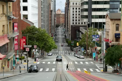
Heather Knight reports on a new study from Marcel Maron, who analyzed all of San Francisco's 6,399 intersections and mapped the existence or lack of crosswalks at each one. Maron's results showed a stark disparity between neighborhoods. "Crosswalk hot spots with clusters of intersections sporting the painted passages are almost entirely located in the northern half of the city, particularly in richer neighborhoods including Pacific Heights, Presidio Heights, Laurel Heights, Alamo Square, Nob Hill, the Financial District and South Beach." Meanwhile, "Crosswalk cold spots, where pedestrians can walk blocks without encountering a crosswalk, are almost entirely in the southern half of the city."
Overall, 58% of San Francisco’s intersections have crosswalks, but their distribution varies widely. In Pacific Heights, 83% of intersections have them, while in Bayview-Hunters Point, 51% do. In the Mission, which has far more traffic and pedestrians than Pacific Heights, 63% of intersections have crosswalks.
Another study Moran conducted in 2020 analyzed the city's nearly 3,000 bus stops and found a similar disparity in amenities like seating, shelters, and signage between the northern and southern halves of the city. "Also, routes with the longest intervals between buses were the least likely to have seats and shelters — making passengers who have to wait the longest do so in the least comfortable way. This, again, despite San Francisco’s claim to be a transit-first city," notes Knight.
Moran argues that these disparities create a vicious cycle, discouraging people from walking or using transit due to safety and comfort concerns. "And then the city can say better bus stops and crosswalks aren’t necessary because people aren’t using those spaces."
FULL STORY: He mapped every crosswalk in S.F. The results show a startling safety gap for some neighborhoods

Connecticut Launches Complete Streets Standards
The new policy calls for sidewalks, bike lanes, and crosswalks on state roads and state-funded road projects.
San Francisco Slow Streets Bucks Citywide Trend, Reducing Injuries by 61 Percent
Low-cost interventions aimed at slowing traffic are making a major impact on road safety.
NACTO Releases Updated Urban Bikeway Guide
The third edition of the nationally recognized road design guide includes detailed design advice for roads that prioritize safety and accessibility for all users.

Alabama: Trump Terminates Settlements for Black Communities Harmed By Raw Sewage
Trump deemed the landmark civil rights agreement “illegal DEI and environmental justice policy.”

Planetizen Federal Action Tracker
A weekly monitor of how Trump’s orders and actions are impacting planners and planning in America.

The 120 Year Old Tiny Home Villages That Sheltered San Francisco’s Earthquake Refugees
More than a century ago, San Francisco mobilized to house thousands of residents displaced by the 1906 earthquake. Could their strategy offer a model for the present?

Opinion: California’s SB 79 Would Improve Housing Affordability and Transit Access
A proposed bill would legalize transit-oriented development statewide.

Record Temperatures Prompt Push for Environmental Justice Bills
Nevada legislators are proposing laws that would mandate heat mitigation measures to protect residents from the impacts of extreme heat.

Downtown Pittsburgh Set to Gain 1,300 New Housing Units
Pittsburgh’s office buildings, many of which date back to the early 20th century, are prime candidates for conversion to housing.
Urban Design for Planners 1: Software Tools
This six-course series explores essential urban design concepts using open source software and equips planners with the tools they need to participate fully in the urban design process.
Planning for Universal Design
Learn the tools for implementing Universal Design in planning regulations.
Clanton & Associates, Inc.
Jessamine County Fiscal Court
Institute for Housing and Urban Development Studies (IHS)
City of Grandview
Harvard GSD Executive Education
Toledo-Lucas County Plan Commissions
Salt Lake City
NYU Wagner Graduate School of Public Service