


The walkway is simpler and faster to build than a sidewalk, letting the city quickly and cost-effectively improve pedestrian safety on important walking corridors.
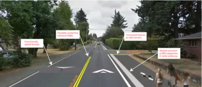
The city of Portland is experimenting with a new type of pedestrian walkway that could "improve walking conditions without the expense or complication of building a full-fledged sidewalk." Jonathan Maus of Bike Portland reports on the "alternative pedestrian walkway," a one-mile pilot project on Portland's Northeast 60th Avenue.
"Identified as a major walking corridor in the city’s pedestrian master plan (Ped PDX, 2019), 60th was like many streets in Cully and other less-developed parts of Portland: it had two general lanes and no space for shoulders, bike lanes or sidewalks. To get the space for a six-foot wide walkway on one side of the street, PBOT shifted the centerline over about four feet. They then leveled and paved the existing gravel shoulder." The walkway is marked with pedestrian markings and crossings feature "zebra-striping, truncated domes (those tiny yellow bumps), and a few plastic delineator wands."
Although not designed as a bikeway, use by bicycles is allowed. "Until PBOT establishes good bikeways nearby, this could become a useful bikeway." The project provides a template for quick, low-cost pedestrian improvements.
FULL STORY: First Look: Portland’s novel ‘alternative pedestrian walkway’

Portland Transportation Bureau Faces ‘Existential’ Cuts
PBOT’s director says the agency’s impending budget shortfall could imperil even basic transportation and infrastructure services.

Audit: Portland’s Vision Zero Needs More Data, Funding
A city audit found that the program has failed to reduce traffic deaths and could benefit from a more systematic approach. Meanwhile, PBOT says it needs more state funding to support road safety projects.
Southeast LA Road Safety Advocates Call for Improved Infrastructure
Streets in southeastern Los Angeles County have a severe lack of protected bike lanes and traffic safety measures, leading to high numbers of fatalities in a community where many residents depend on walking and biking for daily needs.

Alabama: Trump Terminates Settlements for Black Communities Harmed By Raw Sewage
Trump deemed the landmark civil rights agreement “illegal DEI and environmental justice policy.”

Planetizen Federal Action Tracker
A weekly monitor of how Trump’s orders and actions are impacting planners and planning in America.

The 120 Year Old Tiny Home Villages That Sheltered San Francisco’s Earthquake Refugees
More than a century ago, San Francisco mobilized to house thousands of residents displaced by the 1906 earthquake. Could their strategy offer a model for the present?

Ken Jennings Launches Transit Web Series
The Jeopardy champ wants you to ride public transit.

BLM To Rescind Public Lands Rule
The change will downgrade conservation, once again putting federal land at risk for mining and other extractive uses.

Indy Neighborhood Group Builds Temporary Multi-Use Path
Community members, aided in part by funding from the city, repurposed a vehicle lane to create a protected bike and pedestrian path for the summer season.
Urban Design for Planners 1: Software Tools
This six-course series explores essential urban design concepts using open source software and equips planners with the tools they need to participate fully in the urban design process.
Planning for Universal Design
Learn the tools for implementing Universal Design in planning regulations.
Clanton & Associates, Inc.
Jessamine County Fiscal Court
Institute for Housing and Urban Development Studies (IHS)
City of Grandview
Harvard GSD Executive Education
Toledo-Lucas County Plan Commissions
Salt Lake City
NYU Wagner Graduate School of Public Service