


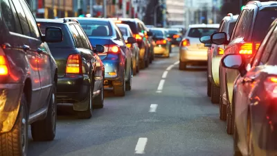
The city saw a 13 percent drop in miles driven per capita in the last five years.

San Francisco is one of the few U.S. cities to reduce its vehicle miles driven (VMT) per capita, according to a StreetLight Data report, which calls the city the “best-performing metro for congestion reduction.” Los Angeles also saw a similar reduction in VMT per capita.
The drop could result from a combination of the high prevalence of remote knowledge-based jobs in the San Francisco Bay Area and broader policy efforts on the part of state and local governments.
Skip Descant, writing in GovTech, explains that California officials consider the impact on VMT when reviewing permits for new developments. According to Laura Rubio-Cornejo, general manager of the Los Angeles Department of Transportation, “any conditions we place on developments are really geared toward improving that type of [walkable, bikeable, transit-oriented] environment. I think that is going to be a big game changer.”
FULL STORY: San Francisco Shows Signs of Reduced Vehicle Use, Congestion


Research Shows More Roads = More Driving
A national study shows, once again, that increasing road supply induces additional vehicle travel, particularly over the long run.

From 9-to-5 to Anytime: How Telecommuting Changes the Traffic Game
Not all cities have benefited equally from congestion relief brought on by shifting commuting patterns.
Report: Americans Are Driving More Than Ever
Average vehicle miles driven rose in almost every major metropolitan area between 2019 and 2024.

Alabama: Trump Terminates Settlements for Black Communities Harmed By Raw Sewage
Trump deemed the landmark civil rights agreement “illegal DEI and environmental justice policy.”

Planetizen Federal Action Tracker
A weekly monitor of how Trump’s orders and actions are impacting planners and planning in America.

The 120 Year Old Tiny Home Villages That Sheltered San Francisco’s Earthquake Refugees
More than a century ago, San Francisco mobilized to house thousands of residents displaced by the 1906 earthquake. Could their strategy offer a model for the present?

Seattle Voters Approve Social Housing Referendum
Voters approved a corporate tax to fund the city’s housing authority despite an opposition campaign funded by Amazon and Microsoft.

The Five Most-Changed American Cities
A ranking of population change, home values, and jobs highlights the nation’s most dynamic and most stagnant regions.

USDOT Repeals Emissions Monitoring Rule
A Biden-era regulation required states to report and plan to reduce transportation-related emissions.
Urban Design for Planners 1: Software Tools
This six-course series explores essential urban design concepts using open source software and equips planners with the tools they need to participate fully in the urban design process.
Planning for Universal Design
Learn the tools for implementing Universal Design in planning regulations.
Clanton & Associates, Inc.
Jessamine County Fiscal Court
Institute for Housing and Urban Development Studies (IHS)
City of Grandview
Harvard GSD Executive Education
Toledo-Lucas County Plan Commissions
Salt Lake City
NYU Wagner Graduate School of Public Service