


European cities tend to be more walkable and transit-accessible—perhaps because they get the three Ds right (density, diversity, and design).

Last week, I went to Europe for the first time in over 20 years, and for the first time ever alone (as opposed to traveling with family or with a guided tour). Rather than going to the usual museums and tourist attractions, I explored Paris and Amsterdam the same way I would explore Detroit or Phoenix: as an urbanist, visiting as many neighborhoods as possible and comparing them to American cities.
Of course, both cities are far more walkable and transit-oriented than most American cities. In both, only about 30 percent of commuters use a car. Why?
Robert Cervero has written that three major elements affect travel patterns: density, diversity and design. Paris and Amsterdam are only moderately different from most American cities in the first two respects, but quite different in the last.
Compact cities tend to be more walkable and transit-friendly, because in a dense, compact city, more people can live within walking distance of shops and transit stops. Paris and Amsterdam are more dense than most of the United States—but not outstandingly so from my New York City perspective. Paris has about 55,000 people per square mile—more than New York City as a whole but less than Manhattan. Amsterdam is much less dense, with a little over 12,000 people per square mile- not many by New York standards, but still comparable to transit-friendly cities like Chicago and San Francisco. Even in Centrum (the most dense of Amsterdam's boroughs) there were only 28,000 people per square mile, only slightly more than the citywide average in New York.
In both cities, I stayed in transit-accessible suburbs rather than in the touristy, expensive core. But even in its suburbs, Paris seemed to have a high diversity of uses; it was very common to see shops on the ground floor of residential blocks, even in suburban Levallois where I stayed. This diversity makes it easier for people to walk to shops. Similarly, Centrum is mostly mixed-use. The post-World War II, suburb-y parts of Amsterdam, by contrast, do have areas dominated by residences. But in these neighborhoods, as in 1920s American streetcar suburbs, a commercial street was usually just a few blocks away.
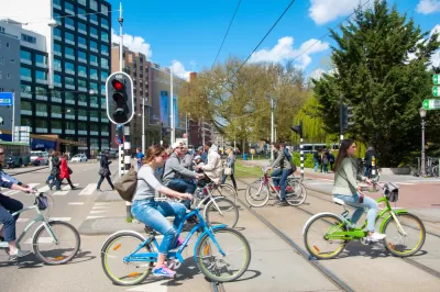
The biggest difference between these cities and American cities, however, relates to design. Even in my Manhattan neighborhood, most street space is reserved for moving automobiles. By contrast, in Paris and Amsterdam there are fewer automobile lanes and more space for pedestrians (and, in Amsterdam, bicycles). In Levallois, I stayed on a two-lane street with one lane for parked cars and only one more lane for moving cars. Amsterdam had far more bike lanes, but also seemed to have a lot of one and two-lane streets. Narrow streets have obvious benefits for pedestrians and bicyclists: traffic is slower, and when you cross the streets you have fewer lanes to cross.
(Note: If you want to see photos of the neighborhoods I visited, the photos on my Facebook page are set as open to the public).

Eurostar Temporarily Closing Two High-Speed Rail Routes
Eurostar is temporarily closing routes from London to Disneyland Paris and London to Amsterdam.

CNU Report Outlines Incremental Steps for More Walkable Suburbs
Transforming suburban sprawl is a massive undertaking, but these small steps can help communities understand their needs and assets and develop clear, actionable goals for the future.

Bicycle Architecture Biennale Showcases Exceptional Projects Around the World
The second biennale in Amsterdam highlights design and infrastructure projects that put biking front and center.

Alabama: Trump Terminates Settlements for Black Communities Harmed By Raw Sewage
Trump deemed the landmark civil rights agreement “illegal DEI and environmental justice policy.”

Planetizen Federal Action Tracker
A weekly monitor of how Trump’s orders and actions are impacting planners and planning in America.

The 120 Year Old Tiny Home Villages That Sheltered San Francisco’s Earthquake Refugees
More than a century ago, San Francisco mobilized to house thousands of residents displaced by the 1906 earthquake. Could their strategy offer a model for the present?

Ken Jennings Launches Transit Web Series
The Jeopardy champ wants you to ride public transit.

BLM To Rescind Public Lands Rule
The change will downgrade conservation, once again putting federal land at risk for mining and other extractive uses.

Indy Neighborhood Group Builds Temporary Multi-Use Path
Community members, aided in part by funding from the city, repurposed a vehicle lane to create a protected bike and pedestrian path for the summer season.
Urban Design for Planners 1: Software Tools
This six-course series explores essential urban design concepts using open source software and equips planners with the tools they need to participate fully in the urban design process.
Planning for Universal Design
Learn the tools for implementing Universal Design in planning regulations.
Clanton & Associates, Inc.
Jessamine County Fiscal Court
Institute for Housing and Urban Development Studies (IHS)
City of Grandview
Harvard GSD Executive Education
Toledo-Lucas County Plan Commissions
Salt Lake City
NYU Wagner Graduate School of Public Service