


Street networks and city blocks, reduced to their fundamental attributes, reveal the vast differences between cities.
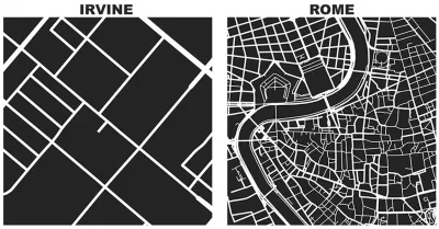
On his personal blog, Geoff Boeing, an urban planning PhD candidate at the University of California, Berkeley, has created a series of illustrations that allows easy comparison of the urban forms of cities as disparate as Rome and Irvine.
Inspired by Great Streets by Allan Jacobs, Boeing used Python and the OSMnx package he created for his dissertation. "With OSMnx we can download a street network from OpenStreetMap for anywhere in the world in just one line of code," explains Boeing.
Every image Boeing displays is cropped to one square mile—in cities like Portland, Irvine, Rome, Paris, and New York. The stark contrast of the images allows for "spatial objectivity," explains Boeing. The process is open source too—Boeing has placed examples and the code to reproduce these diagrams in OSMnx's GitHub repo.
FULL STORY: Square-Mile Street Network Visualization

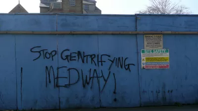
Friday Eye Candy: Turning Gentrification Data Into Art
Herwig Scherabon is a graphic designer featured this week in The Guardian.
Graphic Reveals Cardinal Orientation of Street Grids
Seth Kadish says he was born with an innate sense of direction. As such, he appreciates street grids oriented to cardinal directions. The phenomena interested him enough to create a graphic that visualizes the orientation of 12 urban areas.

Friday Eye Candy: AI Envisions Solutions to the Challenges Facing Cities
Phoenix reimagined for shade. Los Angeles as a place where everybody walks. San Francisco with affordable housing. AI makes a vision of the future possible.

Trump Administration Could Effectively End Housing Voucher Program
Federal officials are eyeing major cuts to the Section 8 program that helps millions of low-income households pay rent.

Planetizen Federal Action Tracker
A weekly monitor of how Trump’s orders and actions are impacting planners and planning in America.

Ken Jennings Launches Transit Web Series
The Jeopardy champ wants you to ride public transit.

Crime Continues to Drop on Philly, San Francisco Transit Systems
SEPTA and BART both saw significant declines in violent crime in the first quarter of 2025.

How South LA Green Spaces Power Community Health and Hope
Green spaces like South L.A. Wetlands Park are helping South Los Angeles residents promote healthy lifestyles, build community, and advocate for improvements that reflect local needs in historically underserved neighborhoods.

Sacramento Plans ‘Quick-Build’ Road Safety Projects
The city wants to accelerate small-scale safety improvements that use low-cost equipment to make an impact at dangerous intersections.
Urban Design for Planners 1: Software Tools
This six-course series explores essential urban design concepts using open source software and equips planners with the tools they need to participate fully in the urban design process.
Planning for Universal Design
Learn the tools for implementing Universal Design in planning regulations.
Heyer Gruel & Associates PA
Ada County Highway District
Institute for Housing and Urban Development Studies (IHS)
City of Grandview
Harvard GSD Executive Education
Toledo-Lucas County Plan Commissions
Salt Lake City
NYU Wagner Graduate School of Public Service