


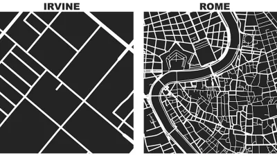
Seth Kadish says he was born with an innate sense of direction. As such, he appreciates street grids oriented to cardinal directions. The phenomena interested him enough to create a graphic that visualizes the orientation of 12 urban areas.
“If you’re like me, and you use the Sun to navigate, you probably appreciate cities with gridded street plans that are oriented in the cardinal directions,” writes Seth Kadish in introducing a cool visualization exercise that produced a graphic representation of the orientation of street grids for 12 metropolitan areas around the United States.
Like many of us, Kadish has noticed how the orientation of each city is as unique as the city itself: “…not all urban planners settled on such a simple layout for road networks. For some developers, topography or water may have gotten in the way. Others may not have appreciated the efficiency of the grid.” To examine the differences in orientation, Kadish created a visualization that compares the relative degree to which city streets are gridded.
Here are a few of Kadish’s observations from the visualization; “The plots reveal some stark trends. Most of the counties considered do conform to a grid pattern. This is particularly pronounced with Chicago, even though much of Cook County is suburban. Denver, Jacksonville, Houston, and Washington, D.C., also have dominant grid patterns that are oriented in the cardinal directions. While Philadelphia and New York are primarily gridded, their orientations are slightly skewed from the traditional N-E-S-W bearings.”
FULL STORY: On and Off the Street Grid: Relative Distributions of Road Orientations

Friday Eye Candy: Comparing a Square Mile of the World's Famous Cities
Street networks and city blocks, reduced to their fundamental attributes, reveal the vast differences between cities.

The Dots of Connectivity and Broken Cultural Links
Connectivity is not just a question of geometry, according to this article by Fanis Grammenos. It's critical to consider what people connect for and how.
A 'Cul-De-Tax' for the Cul-De-Sac?
A recent study studying the contemporary planning profession's rejection of the cul-de-sac includes a proposal to create more economic disincentives for inefficient street grid patterns.

Alabama: Trump Terminates Settlements for Black Communities Harmed By Raw Sewage
Trump deemed the landmark civil rights agreement “illegal DEI and environmental justice policy.”

Study: Maui’s Plan to Convert Vacation Rentals to Long-Term Housing Could Cause Nearly $1 Billion Economic Loss
The plan would reduce visitor accommodation by 25% resulting in 1,900 jobs lost.

Planetizen Federal Action Tracker
A weekly monitor of how Trump’s orders and actions are impacting planners and planning in America.

Wind Energy on the Rise Despite Federal Policy Reversal
The Trump administration is revoking federal support for renewable energy, but demand for new projects continues unabated.

Passengers Flock to Caltrain After Electrification
The new electric trains are running faster and more reliably, leading to strong ridership growth on the Bay Area rail system.

Texas Churches Rally Behind ‘Yes in God’s Back Yard’ Legislation
Religious leaders want the state to reduce zoning regulations to streamline leasing church-owned land to housing developers.
Urban Design for Planners 1: Software Tools
This six-course series explores essential urban design concepts using open source software and equips planners with the tools they need to participate fully in the urban design process.
Planning for Universal Design
Learn the tools for implementing Universal Design in planning regulations.
Caltrans
Smith Gee Studio
Institute for Housing and Urban Development Studies (IHS)
City of Grandview
Harvard GSD Executive Education
Toledo-Lucas County Plan Commissions
Salt Lake City
NYU Wagner Graduate School of Public Service