


A mapping project lead by Facebook's Connectivity Lab is gathering data from all over the atmosphere, and beyond, to make a comprehensive map of the world's buildings.
Tara Golsham shares news about a big data project underway at Facebook with tongue in cheek: "Facebook is making a map of every human-occupied building on Earth so that one day, people in the most remote areas of the world can also worry about what to do when their mom friends them on Facebook."
The mapping project is the work of Facebook's Connectivity Lab, "a group tasked with using drones, satellites, and lasers to improve internet access in developing countries," according to Golsham. For the mapping project, Connectivity Lab "has analyzed 21.6 million square kilometers' worth of satellite imagery — about 350 terabytes of data" to develop a much clearer picture of where buildings and structures are located in remote parts of world. That information is the first step in delivering Internet services to those remote areas.
The Connectivity Lab team has also created a post explaining the technical details of the mapping project.
FULL STORY: Why Facebook is making a map of every building in the world

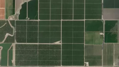
Facebook AI Maps Population Density
Facebook expects to release its worldwide maps of human density in the coming months—potential applications will likely be somewhere on the spectrum between humanitarian and commercial.

How the National Park Service Uses GIS
A new book demonstrates how the National Park Service uses GIS technology to meet its mission and showcases a selection of maps used for effectively managing national parks.
New Tool Puts Miami Development Opportunities on the Map
There's plenty of vacant or underutilized land to be found in Miami-Dade County, if you know where and how to look.

Alabama: Trump Terminates Settlements for Black Communities Harmed By Raw Sewage
Trump deemed the landmark civil rights agreement “illegal DEI and environmental justice policy.”

Planetizen Federal Action Tracker
A weekly monitor of how Trump’s orders and actions are impacting planners and planning in America.

The 120 Year Old Tiny Home Villages That Sheltered San Francisco’s Earthquake Refugees
More than a century ago, San Francisco mobilized to house thousands of residents displaced by the 1906 earthquake. Could their strategy offer a model for the present?

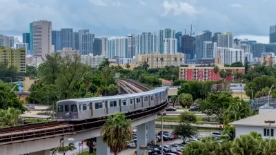
In Both Crashes and Crime, Public Transportation is Far Safer than Driving
Contrary to popular assumptions, public transportation has far lower crash and crime rates than automobile travel. For safer communities, improve and encourage transit travel.

Report: Zoning Reforms Should Complement Nashville’s Ambitious Transit Plan
Without reform, restrictive zoning codes will limit the impact of the city’s planned transit expansion and could exclude some of the residents who depend on transit the most.

Judge Orders Release of Frozen IRA, IIJA Funding
The decision is a victory for environmental groups who charged that freezing funds for critical infrastructure and disaster response programs caused “real and irreparable harm” to communities.
Urban Design for Planners 1: Software Tools
This six-course series explores essential urban design concepts using open source software and equips planners with the tools they need to participate fully in the urban design process.
Planning for Universal Design
Learn the tools for implementing Universal Design in planning regulations.
Clanton & Associates, Inc.
Jessamine County Fiscal Court
Institute for Housing and Urban Development Studies (IHS)
City of Grandview
Harvard GSD Executive Education
Toledo-Lucas County Plan Commissions
Salt Lake City
NYU Wagner Graduate School of Public Service