


Looking for the perfect holiday gift for a planner? Check out these new map books.

Joshua Hammer reviews four coffee-table treasures that illustrate the many entertaining and intellectual cartographic forms.
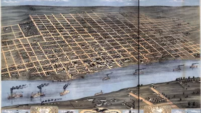
Map: Exploring the World is a collection of 300 celebrated maps spanning 3,000 years: "the most captivating of several new books that explore the power of spatial representations and how they shape our perceptions of reality," according to Hammer.
The Curious Map Book explores the more playful side of maps, with illustrations of puzzles from 18th century Britain, hand-woven rugs from wartime Afghanistan, and Hammer's favorite—a series of anthropomorphic satires. Among these "one exquisite creation, drawn by the lithographic artist and caricaturist Joseph John Goggins, probably in Dublin, in 1870, [that] portrays Europe as a menagerie of grotesque humans and beasts in sometimes bellicose poses."
In his book, Restless Empire: A Historical Atlas of Russia, Ian Barnes narrates a cartographic history of Russia and the Soviet Empire. "Most powerful are his maps of the wars that repeatedly threatened to tear the empire apart, from Napoleon’s doomed invasion in 1812 to Hitler’s Operation Barbarossa in 1941," opines Hammer.
Tim Marshall's ambitious claim to explain everything about the world in ten maps (Prisoners of Geography: Ten Maps That Explain Everything About the World) may seem at times reductionist. However, Hammer finds that Marshall's "insistence on seeing the world through the lens of geography compels a fresh way of looking at maps — not just as objects for orientation or works of art, but as guideposts to the often thorny relations between nations."
FULL STORY: ‘Map: Exploring the World,’ ‘The Curious Map Book’ and More

Mapped: Every Building in the United States
Using data from Microsoft, the New York Times has published an online map showing the placement of every building in the country, in a simple black and white format.
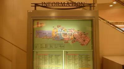
The Future of Mapping is Going Indoors
Cartographers have a new world to map, as technology opens up the interiors of malls, museums, and other large spaces to online exploration.

Today's Cartographers Are Database Engineers
Modern maps are visual representations of millions of points of standardized data.

Alabama: Trump Terminates Settlements for Black Communities Harmed By Raw Sewage
Trump deemed the landmark civil rights agreement “illegal DEI and environmental justice policy.”

Planetizen Federal Action Tracker
A weekly monitor of how Trump’s orders and actions are impacting planners and planning in America.

The 120 Year Old Tiny Home Villages That Sheltered San Francisco’s Earthquake Refugees
More than a century ago, San Francisco mobilized to house thousands of residents displaced by the 1906 earthquake. Could their strategy offer a model for the present?

In Both Crashes and Crime, Public Transportation is Far Safer than Driving
Contrary to popular assumptions, public transportation has far lower crash and crime rates than automobile travel. For safer communities, improve and encourage transit travel.

Report: Zoning Reforms Should Complement Nashville’s Ambitious Transit Plan
Without reform, restrictive zoning codes will limit the impact of the city’s planned transit expansion and could exclude some of the residents who depend on transit the most.

Judge Orders Release of Frozen IRA, IIJA Funding
The decision is a victory for environmental groups who charged that freezing funds for critical infrastructure and disaster response programs caused “real and irreparable harm” to communities.
Urban Design for Planners 1: Software Tools
This six-course series explores essential urban design concepts using open source software and equips planners with the tools they need to participate fully in the urban design process.
Planning for Universal Design
Learn the tools for implementing Universal Design in planning regulations.
Clanton & Associates, Inc.
Jessamine County Fiscal Court
Institute for Housing and Urban Development Studies (IHS)
City of Grandview
Harvard GSD Executive Education
Toledo-Lucas County Plan Commissions
Salt Lake City
NYU Wagner Graduate School of Public Service