


Cartographers have a new world to map, as technology opens up the interiors of malls, museums, and other large spaces to online exploration.
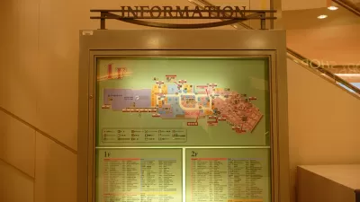
CityMetric reports on the efforts by Google to start mapping the interior of buildings, which presents a whole new area of exploration for cartographers. Sending people into large venues wearing a rucksack contraption, Google is able to map the interior of spaces such as the British Museum in London, allowing viewers to move from the museum’s basement level to the fifth floor to find the location of specific exhibits.
Google has used the rucksack to build up a growing list of indoor maps... Most are large indoor venues, museums or shopping centres – places which often offer their own floorplan maps thanks to their size and the number of services on offer. It makes sense that these maps would eventually transfer to the digital arena, just as outdoor maps have.
Apple appears to be getting into the indoor mapping space as well, launching the “Indoor Survey App”, which CityMetric notes is accessible only through a direct link to the app’s page. “According to the app description, it allows users to map indoor spaces by ‘dropping points’.”
Moving beyond the 2D limitations of Google and Apple Maps, Harvard University is partnering with the Redlands, California-based SmarterBetterCiities to create 3D interior maps of the Harvard campus. SmarterBetterCities uses ESRI’s ArcGIS platform to create 3D models of interior spaces, such as a map prepared for the ESRI User Conference in the San Diego Convention Center, viewable here.
FULL STORY: Why the indoors could be the next frontier for map-makers


Friday Funny: Cartographers Are Hiding an Idyllic Continent
The rest of the world would only spoil it for the mapmakers.

Friday Eye Candy: Charting Road Maps By Hand
In the days before Google Maps, when AAA TripTiks and Thomas Guides ruled the planet…
Friday Eye Candy: Highly Detailed Cold War Era Soviet Maps of the U.S.
A new book sheds light on maps created by cartographers in the Soviet Union that dove into remarkable detail about buildings, transportation networks, and other infrastructure in cities across the United States and around the world.

Alabama: Trump Terminates Settlements for Black Communities Harmed By Raw Sewage
Trump deemed the landmark civil rights agreement “illegal DEI and environmental justice policy.”

Study: Maui’s Plan to Convert Vacation Rentals to Long-Term Housing Could Cause Nearly $1 Billion Economic Loss
The plan would reduce visitor accommodation by 25% resulting in 1,900 jobs lost.

Planetizen Federal Action Tracker
A weekly monitor of how Trump’s orders and actions are impacting planners and planning in America.

Wind Energy on the Rise Despite Federal Policy Reversal
The Trump administration is revoking federal support for renewable energy, but demand for new projects continues unabated.

Passengers Flock to Caltrain After Electrification
The new electric trains are running faster and more reliably, leading to strong ridership growth on the Bay Area rail system.

Texas Churches Rally Behind ‘Yes in God’s Back Yard’ Legislation
Religious leaders want the state to reduce zoning regulations to streamline leasing church-owned land to housing developers.
Urban Design for Planners 1: Software Tools
This six-course series explores essential urban design concepts using open source software and equips planners with the tools they need to participate fully in the urban design process.
Planning for Universal Design
Learn the tools for implementing Universal Design in planning regulations.
Caltrans
Smith Gee Studio
Institute for Housing and Urban Development Studies (IHS)
City of Grandview
Harvard GSD Executive Education
Toledo-Lucas County Plan Commissions
Salt Lake City
NYU Wagner Graduate School of Public Service