


So, I'm out at a site visit with the city engineer last week and we're talking about ways to implement curb extensions to reduce pedestrian exposure to vehicular traffic. We're discussing inexpensive ways to accomplish this, and then on queue, as is the right and obligation of all civil engineers, the ugly villain subject of all things bumped-out rears its head: drainage.

So, I'm out at a site visit with the city engineer last week and we're talking about ways to implement curb extensions to reduce pedestrian exposure to vehicular traffic. We're discussing inexpensive ways to accomplish this, and then on queue, as is the right and obligation of all civil engineers, the ugly villain subject of all things bumped-out rears its head: drainage.
If you've ever attempted to retrofit an intersection with curb extensions (a.k.a bump-outs), you're certain to have run into the havoc that an ill-placed catch basin wreaks on a good-intentioned, simple, concrete extension. Oftentimes, catch basins and drainage paths kill a curb-extension retrofit because the relocation of catch basins triple or quadruple the cost of an otherwise simple implementation. Oh, the frustration! Although I can't offer any magic solutions - and there's just so much ARRA can do for you - there are some ways to get some bang for a lot less buck.
First up is something I have never tried myself, but saw implemented quite effectively in Arcadia, California, a bedroom community of Los Angeles. I observed a streetscapes improvement project along their main street, which apparently ran into a potential deal-breaker when it was learned that to get curb extensions and extended planters, all the catch basins along the corridor would have to be relocated to avoid ponding. Instead of throwing hands and scales in the air and leaving things to rampant speeders, some innovative soul came up with a solution that I have not seen used anywhere else, but could perhaps make life a lot easier for those of us looking to retrofit existing streets. They simply designed short concrete spans as removable panels (presumably for regular cleaning) to serve as a bridge between the existing curb and the new extension "islands". This effectively allows the design to work around existing drainage infrastructure, and avoids the huge costs needed to relocate catch basins. I never had a chance to ask that city's administration about the pros and cons of this solution now that it's been in place for several years, but I suspect that sweeping out detritus and occasional vandalism ("Dude, like, I totally bet you can't lift that concrete panel there, you wussy.") are highest on the list. Anyone see this somewhere else?
As you likely already know, among other things such as keeping pedestrians off the street and six inches higher, curb extensions are beneficial because they physically prevent cars from parking too close to, or within, crosswalks. But in Hoboken, our budget status is so deep in the hole we're not allowed to play with concrete. Our residential streets are tightly packed with on-street parallel parking that , despite state statutes prohibiting parking within 25 feet of the line, oftentimes creeps right up and into crosswalks. Since it is nearly impossible to enforce this throughout the city all the time, and there simply is no money to build curb extensions, we were looking for a simple, inexpensive, and definitive way to prevent cars from parking too close to crosswalks. Enter the lowly vertical delineator.
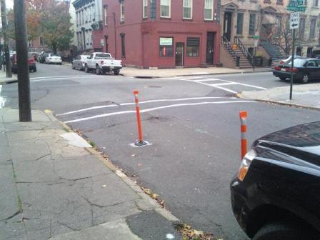
"Hoboken Daylighting" Simply Involves Two Vertical Delineators Per Corner
Step 1: Tow car illegally parked at or in crosswalk. Step 2: Install first pole approximately ten feet from crosswalk and approximately four feet offset from the curb. Step 3: Install second pole an additional ten feet from the first pole at same offset from curb. Step 4: Repeat elsewhere as requested. The beauty of this "Hoboken Daylighting" concept is that it takes ten minutes to install, costs $40, and effectively prevents all but the most absolutely hell-bent, obstinate parkers from infringing upon the sight-distance area critical for pedestrian visibility (Yes, some people indeed drive over these, as unbelievable as it sounds, but I suspect these desperate individuals are members of a vengeful sect that attempts to summon the spirit of Robert Moses every December 18th by smashing two chunks of macadam over a flaming can of Pennzoil, so don't be deterred.)

Hoboken Daylighting Is Installed Here For Both "Critical Approaches"
Again, it ain't pretty, but it gets the job done in a dense urban environment where enforcement must be supplemented by physical preventative measures at critical approaches. When we first started this program a few years back, the poles were a bit unpleasant to look at because there was no laudable track-record against which to contrast their aesthetics. But nowadays, function has overcome form, and Hoboken Daylighting is requested by residents all around town. We're now using an NJDOT system called Plan4Safety to identify highest incident intersections to balance resident requests with critical safety locations, all on a shoestring. Since intersections in Hoboken are typically the convergence of one-way streets, we typically only install Hoboken Daylighting on the "in" approaches, not the "outs". This is because drivers need line-of-sight with pedestrians and other vehicles as they are entering an intersection (truck turning movements is another issue). I hope this is helpful to those of you looking for quick and cheap ways to improve safety at critical corners. If you have questions about Hoboken Daylighting, leave them in the comments below and I'll answer them as best as possible.

Vision Zero at Work: Hoboken Celebrates Seven Years of Zero Traffic Deaths
The New Jersey city implemented simple yet impactful changes to eliminate traffic fatalities.
How Well Will San Francisco’s Daylighting Program Work?
Unlike other efforts to prevent cars from parking near intersections to improve visibility and road safety, San Francisco has no plans to install physical infrastructure to keep vehicles out of danger zones.
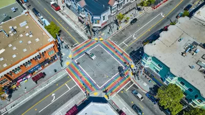
San Francisco Implements ‘Daylighting’ at Intersections
Vehicles are prohibited from parking within 20 feet of a crosswalk as part of the city’s Vision Zero efforts to eliminate traffic deaths and make roads safer.

What ‘The Brutalist’ Teaches Us About Modern Cities
How architecture and urban landscapes reflect the trauma and dysfunction of the post-war experience.

‘Complete Streets’ Webpage Deleted in Federal Purge
Basic resources and information on building bike lanes and sidewalks, formerly housed on the government’s Complete Streets website, are now gone.

The VW Bus is Back — Now as an Electric Minivan
Volkswagen’s ID. Buzz reimagines its iconic Bus as a fully electric minivan, blending retro design with modern technology, a 231-mile range, and practical versatility to offer a stylish yet functional EV for the future.

Healing Through Parks: Altadena’s Path to Recovery After the Eaton Fire
In the wake of the Eaton Fire, Altadena is uniting to restore Loma Alta Park, creating a renewed space for recreation, community gathering, and resilience.

San Diego to Rescind Multi-Unit ADU Rule
The city wants to close a loophole that allowed developers to build apartment buildings on single-family lots as ADUs.

Electric Vehicles for All? Study Finds Disparities in Access and Incentives
A new UCLA study finds that while California has made progress in electric vehicle adoption, disadvantaged communities remain underserved in EV incentives, ownership, and charging access, requiring targeted policy changes to advance equity.
Urban Design for Planners 1: Software Tools
This six-course series explores essential urban design concepts using open source software and equips planners with the tools they need to participate fully in the urban design process.
Planning for Universal Design
Learn the tools for implementing Universal Design in planning regulations.
City of Albany
UCLA Lewis Center for Regional Policy Studies
Mpact (formerly Rail~Volution)
Chaddick Institute at DePaul University
City of Piedmont, CA
Great Falls Development Authority, Inc.
HUDs Office of Policy Development and Research