


In an effort to help officials and tourists in Washington D.C. deal with inauguration crowds, researchers at the University of Maryland have created a "four-dimensional" map that tracks traffic and road conditions in real time.
"With more than 2 million people expected to flood into Washington this Tuesday, the software is a gift to the Washington, D.C., Maryland and Virginia departments of transportation."
"At the university's Center for Advanced Transportation Technology, several large flat-screen TVs are hooked up to what looks like your average PlayStation 3 joystick. Taking hold of the controls, you can fly around 3-D images of the Capitol grounds, Georgetown and virtually every other part of the city."
"The difference from above is what you see below. Models of cars and trucks bustle down Wisconsin Avenue, and on U.S. Route 50 near the Baltimore-Washington Parkway a car is off the road owing to a traffic accident. A few moments later, cars start to slow as rain and sleet falls from the sky. "All of this occurs in real time, hence the fourth dimension," says Pack."
FULL STORY: 4-D Imaging To Help Inauguration Tourists

Data and Maps Aiding Police
Geomapping data is helping police in cities address problem areas, improve unsafe intersections and improve overall efficiency.
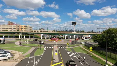
Philadelphia Is Expanding its Network of Roundabouts
Roundabouts are widely shown to decrease traffic speed, reduce congestion, and improve efficiency.
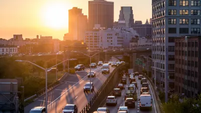
USDOT Threatens to Pull New York Highway Funding
The Trump administration wants the state to kill New York City’s congestion pricing program despite its demonstrated success.

Trump Administration Could Effectively End Housing Voucher Program
Federal officials are eyeing major cuts to the Section 8 program that helps millions of low-income households pay rent.

Planetizen Federal Action Tracker
A weekly monitor of how Trump’s orders and actions are impacting planners and planning in America.

Ken Jennings Launches Transit Web Series
The Jeopardy champ wants you to ride public transit.

Rebuilding Smarter: How LA County Is Guiding Fire-Ravaged Communities Toward Resilience
Los Angeles County is leading a coordinated effort to help fire-impacted communities rebuild with resilience by providing recovery resources, promoting fire-wise design, and aligning reconstruction with broader sustainability and climate goals.

When Borders Blur: Regional Collaboration in Action
As regional challenges outgrow city boundaries, “When Borders Blur” explores how cross-jurisdictional collaboration can drive smarter, more resilient urban planning, sharing real-world lessons from thriving partnerships across North America.

Philadelphia Is Expanding its Network of Roundabouts
Roundabouts are widely shown to decrease traffic speed, reduce congestion, and improve efficiency.
Urban Design for Planners 1: Software Tools
This six-course series explores essential urban design concepts using open source software and equips planners with the tools they need to participate fully in the urban design process.
Planning for Universal Design
Learn the tools for implementing Universal Design in planning regulations.
Ada County Highway District
Clanton & Associates, Inc.
Jessamine County Fiscal Court
Institute for Housing and Urban Development Studies (IHS)
City of Grandview
Harvard GSD Executive Education
Toledo-Lucas County Plan Commissions
Salt Lake City
NYU Wagner Graduate School of Public Service