


The National Guard at Fort Indiantown Gap uses GIS technology and land management strategies to balance military training with conservation efforts, ensuring the survival of the rare eastern regal fritillary butterfly.
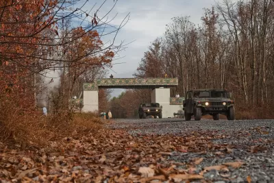
At Pennsylvania’s Fort Indiantown Gap National Guard Training Center, thousands of soldiers train annually in live-fire exercises, yet the base also serves as the last natural home of the eastern regal fritillary butterfly. Rather than relocating military activities, conservationists and military land managers have embraced the disturbances caused by training exercises as essential to the butterfly’s survival. Using Geographic Information System (GIS) technology, biologists track butterfly populations, analyze habitat conditions, and implement land management strategies such as prescribed burns, mowing, and planting violets—the butterfly’s primary host plant. The controlled environmental disruptions help maintain the open grasslands required for the species to thrive, preventing reforestation that would otherwise eliminate its habitat.
As reported by Chris Oxendine and Sunny Fleming, the National Guard has been actively managing the butterfly’s habitat since 1992, using GIS-powered tools to map vegetation, track species populations, and plan conservation efforts. The partnership between Fort Indiantown Gap, the U.S. Fish and Wildlife Service (FWS), and state conservation agencies has been crucial in monitoring and expanding habitat availability. The violet plant, critical for caterpillar survival, flourishes in areas with frequent disturbances from both training activities and prescribed burns. Conservationists have also developed new butterfly reintroduction sites in Pennsylvania, using GIS apps like ArcGIS Survey123 to engage students and volunteers in tracking population changes and nectar sources.
Despite these efforts, the eastern regal fritillary butterfly remains at risk, with the FWS recently proposing to add it to the endangered species list. Conservationists continue refining their strategies, leveraging GIS to adapt and enhance conservation initiatives in real time. Data-sharing across organizations enables scientists to monitor conditions at multiple sites without delays, improving decision-making and habitat management. The ongoing efforts at Fort Indiantown Gap demonstrate how military training and ecological preservation can coexist, using technology and strategic land management to protect a fragile species in an unlikely setting.
FULL STORY: Butterflies and Bombs: How the National Guard Plays a Vital Role in Species Conservation


Study: How Urban Parks Can Support Biodiversity
Conservation and recreation can go hand in hand in urban green spaces designed to serve both humans and local wildlife.

BLM To Rescind Public Lands Rule
The change will downgrade conservation, once again putting federal land at risk for mining and other extractive uses.
What Forest Service Cuts Mean for Cities
U.S. Forest Service employees work on projects that have impacts far beyond remote, rural wilderness areas.

Alabama: Trump Terminates Settlements for Black Communities Harmed By Raw Sewage
Trump deemed the landmark civil rights agreement “illegal DEI and environmental justice policy.”

Planetizen Federal Action Tracker
A weekly monitor of how Trump’s orders and actions are impacting planners and planning in America.

The 120 Year Old Tiny Home Villages That Sheltered San Francisco’s Earthquake Refugees
More than a century ago, San Francisco mobilized to house thousands of residents displaced by the 1906 earthquake. Could their strategy offer a model for the present?

LA’s Tree Emergency Goes Beyond Vandalism
After a vandal destroyed dozens of downtown LA trees, Mayor Karen Bass vowed to replace them. Days later, she slashed the city’s tree budget.

Sacramento Leads Nation With Bus-Mounted Bike Lane Enforcement Cameras
The city is the first to use its bus-mounted traffic enforcement system to cite drivers who park or drive in bike lanes.

Seattle Voters Approve Social Housing Referendum
Voters approved a corporate tax to fund the city’s housing authority despite an opposition campaign funded by Amazon and Microsoft.
Urban Design for Planners 1: Software Tools
This six-course series explores essential urban design concepts using open source software and equips planners with the tools they need to participate fully in the urban design process.
Planning for Universal Design
Learn the tools for implementing Universal Design in planning regulations.
Ada County Highway District
Clanton & Associates, Inc.
Jessamine County Fiscal Court
Institute for Housing and Urban Development Studies (IHS)
City of Grandview
Harvard GSD Executive Education
Toledo-Lucas County Plan Commissions
Salt Lake City
NYU Wagner Graduate School of Public Service