


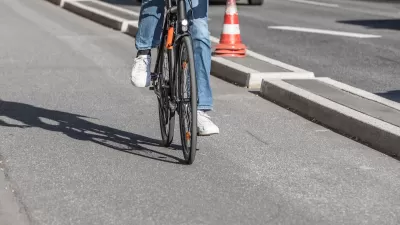
The new tool highlights the streets that pose the biggest risk to pedestrians and other road users.

Officials in Louisville, Kentucky have a new tool to assess which local roads are in need of safety improvements as part of its Vision Zero effort to elimiate traffic deaths, reports Jacob Munoz for Louisville Public Media. “More than 900 people died in Louisville from surface road crashes from 2016-23, and nearly 4,200 others were suspected to have been seriously injured in collisions.”
“Louisville Metro Government’s Vision Zero initiative, which aims to strengthen traffic safety, released its first High Injury Network map in January. The tool provides a priority list of 53 corridors that officials can consider for safety improvements.” The roads in the network make up 5 percent of non-interstate miles in the city, but experience over half of fatal and serious injury crashes. “Most of the high-risk roads identified on the map are state-owned, meaning the Kentucky Transportation Cabinet would need to sign off on improvement projects,” Munoz adds. The city says the map is already helping guide decisions on infrastructure improvements.
FULL STORY: Louisville’s High Injury Network could help prioritize improving safety on certain roads

Southeast LA Road Safety Advocates Call for Improved Infrastructure
Streets in southeastern Los Angeles County have a severe lack of protected bike lanes and traffic safety measures, leading to high numbers of fatalities in a community where many residents depend on walking and biking for daily needs.

Jacksonville Takes Action on Vision Zero
The city is implementing its first-ever Vision Zero Action Plan in an effort to reduce pedestrian and cyclist deaths and serious injuries.

US Street Design Manual Inches Toward Safer Roads
The guiding document for U.S. road design is starting to recognize the needs of people walking and biking, but safe streets advocates say more significant changes are needed to reduce the high number of pedestrian deaths and improve connectivity for all road users.

Study: Maui’s Plan to Convert Vacation Rentals to Long-Term Housing Could Cause Nearly $1 Billion Economic Loss
The plan would reduce visitor accommodation by 25,% resulting in 1,900 jobs lost.

North Texas Transit Leaders Tout Benefits of TOD for Growing Region
At a summit focused on transit-oriented development, policymakers discussed how North Texas’ expanded light rail system can serve as a tool for economic growth.

Why Should We Subsidize Public Transportation?
Many public transit agencies face financial stress due to rising costs, declining fare revenue, and declining subsidies. Transit advocates must provide a strong business case for increasing public transit funding.

How to Make US Trains Faster
Changes to boarding platforms and a switch to electric trains could improve U.S. passenger rail service without the added cost of high-speed rail.

Columbia’s Revitalized ‘Loop’ Is a Hub for Local Entrepreneurs
A focus on small businesses is helping a commercial corridor in Columbia, Missouri thrive.

Invasive Insect Threatens Minnesota’s Ash Forests
The Emerald Ash Borer is a rapidly spreading invasive pest threatening Minnesota’s ash trees, and homeowners are encouraged to plant diverse replacement species, avoid moving ash firewood, and monitor for signs of infestation.
Urban Design for Planners 1: Software Tools
This six-course series explores essential urban design concepts using open source software and equips planners with the tools they need to participate fully in the urban design process.
Planning for Universal Design
Learn the tools for implementing Universal Design in planning regulations.
City of Santa Clarita
Ascent Environmental
Institute for Housing and Urban Development Studies (IHS)
City of Grandview
Harvard GSD Executive Education
Toledo-Lucas County Plan Commissions
Salt Lake City
NYU Wagner Graduate School of Public Service