


Esri Press recently published a digital book called Mapping the Nation which demonstrates how a geographic approach guides important decisions and addresses challenges around the globe.
Published by Esri Press, Mapping the Nation: Creating the World We Want to See highlights how geography and a geographic approach guide important planning and policy decisions around the world. The book contains a wide variety of stories first posted on Esri Blog and explains how geographic information system (GIS) provides a means to examine and explore the dimensions of challenges, prioritizing actions based on mapping, evidence, and analysis.
Mapping the Nation is organized by the following themes or topics:
- Climate Action
- Equity and Social Justice
- Environment
- Conservation
- Humanitarian Assistance
- Public Safety
- Smart Planning
- Infrastructure
- Sustainability
For anyone interested in how GIS is helping to solve real-world challenges, this book should be a tremendous resource. This beautiful and informative digital book is available for download on the Esri website.
FULL STORY: Mapping the Nation - Inspiring Stories of National Government GIS Work


New Book Shows How Geographic Technology Tackles Global Challenges
In his new book, Jack Dangermond explores the transformative impact of GIS technology in solving global challenges through spatial data, highlighting its widespread application across sectors and its potential to design sustainable futures.

Building Healthier Communities: The Role of GIS in Park Planning
Integrating Geographic Information Systems (GIS) into park planning enhances community health by promoting physical activity, supporting mental well-being, fostering social connectedness, and addressing public health crises and climate change.
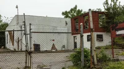
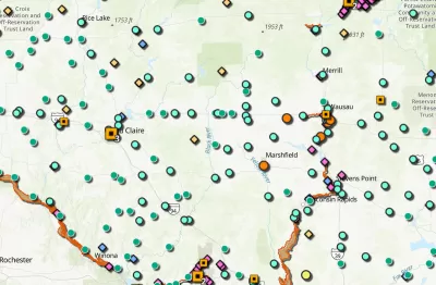
Map Identifies DeKalb County Brownfield Sites
The GIS tool is designed to help developers find vacant and blighted lots that could be restored for new housing or other uses.

Alabama: Trump Terminates Settlements for Black Communities Harmed By Raw Sewage
Trump deemed the landmark civil rights agreement “illegal DEI and environmental justice policy.”

Planetizen Federal Action Tracker
A weekly monitor of how Trump’s orders and actions are impacting planners and planning in America.

The 120 Year Old Tiny Home Villages That Sheltered San Francisco’s Earthquake Refugees
More than a century ago, San Francisco mobilized to house thousands of residents displaced by the 1906 earthquake. Could their strategy offer a model for the present?

Ken Jennings Launches Transit Web Series
The Jeopardy champ wants you to ride public transit.

BLM To Rescind Public Lands Rule
The change will downgrade conservation, once again putting federal land at risk for mining and other extractive uses.

Indy Neighborhood Group Builds Temporary Multi-Use Path
Community members, aided in part by funding from the city, repurposed a vehicle lane to create a protected bike and pedestrian path for the summer season.
Urban Design for Planners 1: Software Tools
This six-course series explores essential urban design concepts using open source software and equips planners with the tools they need to participate fully in the urban design process.
Planning for Universal Design
Learn the tools for implementing Universal Design in planning regulations.
Clanton & Associates, Inc.
Jessamine County Fiscal Court
Institute for Housing and Urban Development Studies (IHS)
City of Grandview
Harvard GSD Executive Education
Toledo-Lucas County Plan Commissions
Salt Lake City
NYU Wagner Graduate School of Public Service