


The GIS tool is designed to help developers find vacant and blighted lots that could be restored for new housing or other uses.
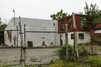
A new GIS tool will help developers in DeKalb County identify “blighted or underused sites” in the region, as well as financial incentives to help move redevelopment projects forward.
According to an article by Josh Green in Urbanize Atlanta, “The layered GIS map is designed to bring brownfield sites to light in a digestible, one-stop-shop way, with pertinent details such as ownership and type of potential hazard listed for hundreds of properties.” The map includes the city of Atlanta.
Although brownfield are defined as sites impacted by environmental contamination, “not all sites on DeKalb’s GIS page need remediation, per the mapping tool.” Local economic development authority Decide DeKalb, who collaborated with the county on the tool, plans to help developers find potential funding sources for site cleanup efforts.
FULL STORY: New tool helps investors find janky development sites across DeKalb


Revitalizing Cities Through Soil Health, Green Spaces, and Nature-Based Remediation
Investing in soil health, urban parks, and nature-based solutions for brownfield remediation is essential for creating resilient cities, restoring ecosystems, and improving community well-being.

New Book Shows How Geographic Technology Tackles Global Challenges
In his new book, Jack Dangermond explores the transformative impact of GIS technology in solving global challenges through spatial data, highlighting its widespread application across sectors and its potential to design sustainable futures.

Building Healthier Communities: The Role of GIS in Park Planning
Integrating Geographic Information Systems (GIS) into park planning enhances community health by promoting physical activity, supporting mental well-being, fostering social connectedness, and addressing public health crises and climate change.

Study: Maui’s Plan to Convert Vacation Rentals to Long-Term Housing Could Cause Nearly $1 Billion Economic Loss
The plan would reduce visitor accommodation by 25,% resulting in 1,900 jobs lost.

North Texas Transit Leaders Tout Benefits of TOD for Growing Region
At a summit focused on transit-oriented development, policymakers discussed how North Texas’ expanded light rail system can serve as a tool for economic growth.

Using Old Oil and Gas Wells for Green Energy Storage
Penn State researchers have found that repurposing abandoned oil and gas wells for geothermal-assisted compressed-air energy storage can boost efficiency, reduce environmental risks, and support clean energy and job transitions.

Private Donations Propel Early Restoration of Palisades Playground
Los Angeles has secured over $1.3 million in private funding to restore the Pacific Palisades playground months ahead of schedule, creating a modern, accessible space that supports community healing after recent wildfires.

From Blight to Benefit: Early Results From California’s Equitable Cleanup Program
The Equitable Community Revitalization Grant (ECRG) program is reshaping brownfield redevelopment by prioritizing projects in low-income and environmental justice communities, emphasizing equity, transparency, and community benefits.

Planting Relief: Tackling Las Vegas Heat One Tree at a Time
Nevada Plants, a Las Vegas-based nonprofit, is combating the city’s extreme urban heat by giving away trees to residents in underserved neighborhoods, promoting shade, sustainability, and community health.
Urban Design for Planners 1: Software Tools
This six-course series explores essential urban design concepts using open source software and equips planners with the tools they need to participate fully in the urban design process.
Planning for Universal Design
Learn the tools for implementing Universal Design in planning regulations.
Ascent Environmental
Borough of Carlisle
Institute for Housing and Urban Development Studies (IHS)
City of Grandview
Harvard GSD Executive Education
Toledo-Lucas County Plan Commissions
Salt Lake City
NYU Wagner Graduate School of Public Service