


The project aims to bring zoning data from around the country into one database, making it easier for planners and researchers to compare policies and their impacts.
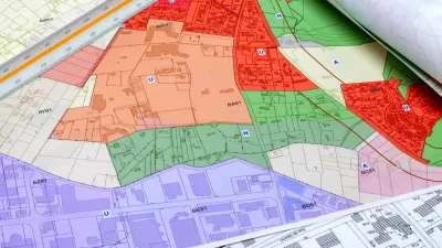
An article in PD&R Edge highlights progress on the National Zoning Atlas, an effort to consolidate nationwide zoning data into one GIS database to let researchers analyze and compare zoning policies and their effects. “The purpose of the atlas is to offer insight into zoning’s effects and democratize land use decisionmaking through comprehensive, digitized, and user-friendly zoning information.”
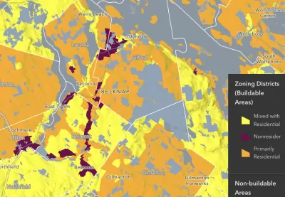
The creators of the Zoning Atlas say “the decentralization of zoning laws has hindered the identification of problems arising from land use regulations.” The effort is already underway in 21 states, and almost complete in New Hampshire.
“An ongoing challenge that the atlas can help address is the obfuscating effects of complex and competing land use interests to reform.” As the article explains, “Aggregating this information makes the scale of statewide challenges more readily apparent and could bring stakeholders on board to address the collective action problems that intricate zoning systems pose.”
FULL STORY: Creating the National Zoning Atlas


National Zoning Atlas Expands
The online tool can help city and state officials understand where zoning codes need reform and how they compare to other localities.
How a National Zoning Atlas Can Clarify a Legal Patchwork
A massive effort is underway to compile local zoning regulations and other laws that impact how and where housing is built.

Report: Zoning Reforms Should Complement Nashville’s Ambitious Transit Plan
Without reform, restrictive zoning codes will limit the impact of the city’s planned transit expansion and could exclude some of the residents who depend on transit the most.

Alabama: Trump Terminates Settlements for Black Communities Harmed By Raw Sewage
Trump deemed the landmark civil rights agreement “illegal DEI and environmental justice policy.”

Planetizen Federal Action Tracker
A weekly monitor of how Trump’s orders and actions are impacting planners and planning in America.

The 120 Year Old Tiny Home Villages That Sheltered San Francisco’s Earthquake Refugees
More than a century ago, San Francisco mobilized to house thousands of residents displaced by the 1906 earthquake. Could their strategy offer a model for the present?

BLM To Rescind Public Lands Rule
The change will downgrade conservation, once again putting federal land at risk for mining and other extractive uses.

Indy Neighborhood Group Builds Temporary Multi-Use Path
Community members, aided in part by funding from the city, repurposed a vehicle lane to create a protected bike and pedestrian path for the summer season.

Congestion Pricing Drops Holland Tunnel Delays by 65 Percent
New York City’s contentious tolling program has yielded improved traffic and roughly $100 million in revenue for the MTA.
Urban Design for Planners 1: Software Tools
This six-course series explores essential urban design concepts using open source software and equips planners with the tools they need to participate fully in the urban design process.
Planning for Universal Design
Learn the tools for implementing Universal Design in planning regulations.
Clanton & Associates, Inc.
Jessamine County Fiscal Court
Institute for Housing and Urban Development Studies (IHS)
City of Grandview
Harvard GSD Executive Education
Toledo-Lucas County Plan Commissions
Salt Lake City
NYU Wagner Graduate School of Public Service