


The online tool can help city and state officials understand where zoning codes need reform and how they compare to other localities.

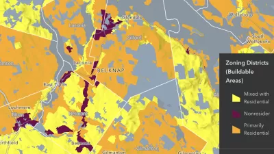
The National Zoning Atlas, a project that seeks to help citizens and policymakers understand the zoning landscape in their areas, is expanding its reach rapidly, reports Elizabeth Daigneau in Route Fifty.
“Last week, the project announced the launch of the Arizona Zoning Atlas. Roughly 36 states have been mapped, some in their entirety and others just in certain metro areas or jurisdictions.” Data is almost complete for New Mexico and Nevada, with metro areas in the works in Colorado, New York, and North Carolina.
The project lets viewers compare zoning codes and access data about lot sizes, parking requirements, and other regulations. Vermont, the state with the largest average lot size at 1.8 acres, used the atlas maps to highlight the need for reduced lot sizes. “State officials used the Vermont Zoning Atlas to show residents how most Vermont towns disappear from the map when a user selects for areas where single-family homes are allowed on lots less than one-quarter acre.”
FULL STORY: See how your state uses zoning codes to control land use

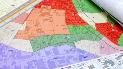
How a National Zoning Atlas Can Clarify a Legal Patchwork
A massive effort is underway to compile local zoning regulations and other laws that impact how and where housing is built.
National Zoning Atlas Makes Headway
The project aims to bring zoning data from around the country into one database, making it easier for planners and researchers to compare policies and their impacts.

Opinion: California’s SB 79 Would Improve Housing Affordability and Transit Access
A proposed bill would legalize transit-oriented development statewide.

Trump Administration Could Effectively End Housing Voucher Program
Federal officials are eyeing major cuts to the Section 8 program that helps millions of low-income households pay rent.

Planetizen Federal Action Tracker
A weekly monitor of how Trump’s orders and actions are impacting planners and planning in America.

Ken Jennings Launches Transit Web Series
The Jeopardy champ wants you to ride public transit.

Crime Continues to Drop on Philly, San Francisco Transit Systems
SEPTA and BART both saw significant declines in violent crime in the first quarter of 2025.

How South LA Green Spaces Power Community Health and Hope
Green spaces like South L.A. Wetlands Park are helping South Los Angeles residents promote healthy lifestyles, build community, and advocate for improvements that reflect local needs in historically underserved neighborhoods.

Sacramento Plans ‘Quick-Build’ Road Safety Projects
The city wants to accelerate small-scale safety improvements that use low-cost equipment to make an impact at dangerous intersections.
Urban Design for Planners 1: Software Tools
This six-course series explores essential urban design concepts using open source software and equips planners with the tools they need to participate fully in the urban design process.
Planning for Universal Design
Learn the tools for implementing Universal Design in planning regulations.
Heyer Gruel & Associates PA
Ada County Highway District
Institute for Housing and Urban Development Studies (IHS)
City of Grandview
Harvard GSD Executive Education
Toledo-Lucas County Plan Commissions
Salt Lake City
NYU Wagner Graduate School of Public Service