


A new transit station area plan is reaching the finishing line for the Huntington Metro station, serving the WMATA’s Yellow Line in Northern Virginia.
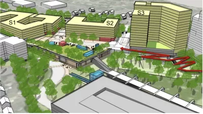
The area surrounding the Huntington Metro station in Fairfax County, Virginia, could soon have a new transit station area plan, prioritizing new transit oriented development that allows for mixed-use development, inclusionary zoning, and additional building heights.
Matt Blitz reports on the approval of the plan amendment by the Fairfax County Planning Commission on November 16. Blitz summarizes the plan as follows:
The plan calls for a mixed-use development on the site including 382,00 square feet of office, retail, and community-use space, a civic plaza, more urban park space, a network of bike and pedestrian paths, a possible hotel, and 15,000 residential units with a minimum of 15% of those being affordable.
Some of the political compromises reached during the plan’s development include lower building heights near homes on Biscayne Drive—85 feet instead of the original 200 feet.
The Fairfax County Board of Supervisors is expected to consider the plan amendment on December 6.
FULL STORY: Huntington Metro area development plan passes planning commission with big height reduction

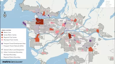
Vancouver Approves New Metro 2050 Regional Plan
The region around Vancouver in British Columbia has a new 30-year regional plan.

New Plans for Transit Oriented Development in South Central L.A.
Los Angeles County recently adopted the Florence-Firestone Transit Oriented District Specific Plan.
Feds to Award $13 Million for Transit Oriented Development Planning
A newly bolstered competitive grant program administered by the Federal Transit Administration has announced a new round of funding.

Alabama: Trump Terminates Settlements for Black Communities Harmed By Raw Sewage
Trump deemed the landmark civil rights agreement “illegal DEI and environmental justice policy.”

Planetizen Federal Action Tracker
A weekly monitor of how Trump’s orders and actions are impacting planners and planning in America.

The 120 Year Old Tiny Home Villages That Sheltered San Francisco’s Earthquake Refugees
More than a century ago, San Francisco mobilized to house thousands of residents displaced by the 1906 earthquake. Could their strategy offer a model for the present?

Ken Jennings Launches Transit Web Series
The Jeopardy champ wants you to ride public transit.

BLM To Rescind Public Lands Rule
The change will downgrade conservation, once again putting federal land at risk for mining and other extractive uses.

Indy Neighborhood Group Builds Temporary Multi-Use Path
Community members, aided in part by funding from the city, repurposed a vehicle lane to create a protected bike and pedestrian path for the summer season.
Urban Design for Planners 1: Software Tools
This six-course series explores essential urban design concepts using open source software and equips planners with the tools they need to participate fully in the urban design process.
Planning for Universal Design
Learn the tools for implementing Universal Design in planning regulations.
Clanton & Associates, Inc.
Jessamine County Fiscal Court
Institute for Housing and Urban Development Studies (IHS)
City of Grandview
Harvard GSD Executive Education
Toledo-Lucas County Plan Commissions
Salt Lake City
NYU Wagner Graduate School of Public Service