


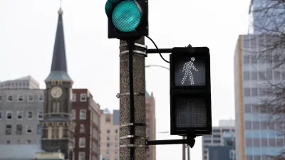
Bellevue, Washington is acting on the data and giving pedestrians head starts at busy intersections around in the city’s downtown.
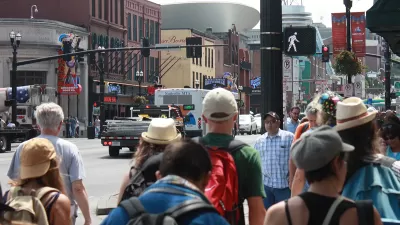
Bellevue, Washington is implementing Leading Pedestrian Intervals (LPIs) on crosswalks around its downtown, according to an article by Christopher Randels for the Urbanist.
“This change…helps to reduce collisions between pedestrians and drivers by making people walking in the crosswalk more visible to drivers before they turn,” reports Randels. LPIs have already demonstrated significant safety benefits in the city, according to Randels: “Analysis from a 2020 pilot program across 20 intersections Downtown and in Crossroads revealed that LPI helped reduce near-misses between people driving and walking by 42%.”
The city of Seattle has its own data to support the safety benefits of LPIs, according to Randel: “A parallel analysis by Seattle’s Department of Transportation across 300 LPI intersections in that city showed a 48% reduction in turning collisions between drivers and pedestrians.” New York City also has a successful record with LPIs.
The article includes more details about where and why (including low-cost implementation for the latter) is Bellevue is rolling out the pedestrian safety improvement in the source article linked below.
FULL STORY: Bellevue Implements Strategies to Protect People Walking and Rolling Downtown


Proposed Bill Would Direct Funds to Road Safety
The Sarah Debbink Langenkamp Active Transportation Safety Act was spurred by the death of a U.S. diplomat who was killed on her bicycle.
Milwaukee Announces 60 Traffic Calming Projects for 2025
The city has successfully reduced traffic deaths and aims to eliminate them completely within the next decade.
Has Progress on Travel Safety Run Off the Road?
Changing technology and rebuilding infrastructure to improve road safety are long-term strategies. How can enforcement and interventions that influence driver behavior make a difference in reducing traffic deaths sooner?

Alabama: Trump Terminates Settlements for Black Communities Harmed By Raw Sewage
Trump deemed the landmark civil rights agreement “illegal DEI and environmental justice policy.”

Planetizen Federal Action Tracker
A weekly monitor of how Trump’s orders and actions are impacting planners and planning in America.

The 120 Year Old Tiny Home Villages That Sheltered San Francisco’s Earthquake Refugees
More than a century ago, San Francisco mobilized to house thousands of residents displaced by the 1906 earthquake. Could their strategy offer a model for the present?

Ken Jennings Launches Transit Web Series
The Jeopardy champ wants you to ride public transit.

BLM To Rescind Public Lands Rule
The change will downgrade conservation, once again putting federal land at risk for mining and other extractive uses.

Indy Neighborhood Group Builds Temporary Multi-Use Path
Community members, aided in part by funding from the city, repurposed a vehicle lane to create a protected bike and pedestrian path for the summer season.
Urban Design for Planners 1: Software Tools
This six-course series explores essential urban design concepts using open source software and equips planners with the tools they need to participate fully in the urban design process.
Planning for Universal Design
Learn the tools for implementing Universal Design in planning regulations.
Clanton & Associates, Inc.
Jessamine County Fiscal Court
Institute for Housing and Urban Development Studies (IHS)
City of Grandview
Harvard GSD Executive Education
Toledo-Lucas County Plan Commissions
Salt Lake City
NYU Wagner Graduate School of Public Service