


The city will reduce vehicle lanes and build a protected multi-use trail including bioswales and other water retention features on its ‘secret highway.’
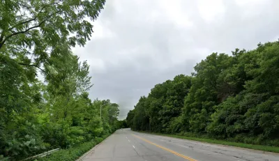
An underused stretch of a Milwaukee road will be transformed into “an environmentally and people-friendly corridor,” writes Jeramey Jannene in Urban Milwaukee.
The strip is located on 1st Street, sandwiched between the Kinnickinnic River and a steep hill. As Jannene explains, “There are no sidewalks or pedestrian accommodations to be found on the approximately half-mile, four-lane stretch, and there is little traffic. There are no homes or businesses. The only driveway is a chained-off ramp to a Deep Tunnel access point.” Now, the city has announced it will reduce vehicle lanes from four to two and add a 10-foot-wide pedestrian and bike path and bioswale.
The design will increase safety for pedestrians and cyclists and also improve drainage by reducing paved surface area. “The bioswales and other environmental features are expected to add almost 91,000 gallons of storm water storage capacity, and 40 trees are expected to be planted.”
The project is funded in part by grants from the Milwaukee Metropolitan Sewerage District and the National Fish and Wildlife Foundation’s Sustain Our Great Lakes program.
FULL STORY: Milwaukee Will Shrink Its Secret Highway

Indy Neighborhood Group Builds Temporary Multi-Use Path
Community members, aided in part by funding from the city, repurposed a vehicle lane to create a protected bike and pedestrian path for the summer season.
Milwaukee Announces 60 Traffic Calming Projects for 2025
The city has successfully reduced traffic deaths and aims to eliminate them completely within the next decade.
Milwaukee Traffic Safety Projects To Receive $8.5 Million in TIF Funds
The city hopes to combat a growing reckless driving 'crisis' with traffic calming, bike lanes, and other projects aimed at improving roadway safety.

Trump Administration Could Effectively End Housing Voucher Program
Federal officials are eyeing major cuts to the Section 8 program that helps millions of low-income households pay rent.

Planetizen Federal Action Tracker
A weekly monitor of how Trump’s orders and actions are impacting planners and planning in America.

Ken Jennings Launches Transit Web Series
The Jeopardy champ wants you to ride public transit.

How Project Connect Would Change ‘The Drag’
A popular — and sometimes deadly — Austin road will exchange car lanes for light rail.

Milwaukee Road to Get Complete Streets Upgrades
The city will reduce vehicle lanes and build a protected multi-use trail including bioswales and other water retention features on its ‘secret highway.’

Tackling Soil Contamination With Nature-Based Solutions
Los Angeles County residents and experts are turning to nature-based methods like bioremediation to address long-standing and fire-exacerbated soil contamination without resorting to costly and disruptive removal.
Urban Design for Planners 1: Software Tools
This six-course series explores essential urban design concepts using open source software and equips planners with the tools they need to participate fully in the urban design process.
Planning for Universal Design
Learn the tools for implementing Universal Design in planning regulations.
Ada County Highway District
Clanton & Associates, Inc.
Jessamine County Fiscal Court
Institute for Housing and Urban Development Studies (IHS)
City of Grandview
Harvard GSD Executive Education
Toledo-Lucas County Plan Commissions
Salt Lake City
NYU Wagner Graduate School of Public Service