


Technology
Legal Battle Over Transportation Network Companies Shifts to Chicago
Chicago political leaders are floating a pair of competing bills that would regulate transportation network companies like Uber, Lyft, and Sidecar. Cab companies are pushing for legislation, seeking a “level playing field” in the market.
Catastrophic Mud Slide in Washington—Could it Have Been Prevented?
The death toll in this rural area 55 miles north of Seattle in Snohomish County is expected to rise. Rain had saturated the ground and led to the collapse of a hillside about 600 feet high and 1,500 feet long. But was the slide foreseeable?
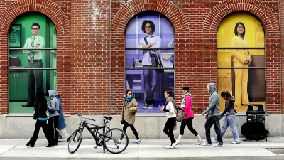
The Technology of Walkability
A recent article explores the promise—and potential pitfalls—of new technology to support the growing popularity of urban pedestrianism.
Report: New Techniques and Technology for Monitoring Active Transportation
The growing popularity of active transportation requires planners and advocates to better survey how, where, and when people are biking and walking. A new study by the Transportation Research Board shares the cutting edge of survey techniques.
Regulation Success Story: Diesel Emissions Greatly Reduced
Thanks to the 2010 federal requirement of ultra-low sulfur diesel fuel and new Tier 4 emissions standards by the EPA, particulate emissions from non-road diesel engines, including agricultural and construction equipment, have been reduced by 99%.
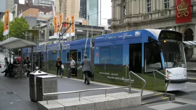
Transit + Technology: Revitalizing Public Transportation for Smarter Communities
Neil Roberts shares details of Melbourne's Yarra Trams, which has exceeded its service delivery and punctuality goals by the use of intelligent transit technology like sensors, the tramTRACKER app, and mobile work stations for employees.
Web-Tool Maps Real-Time Deforestation
A new web-based program, Global Forest Watch, provides access to almost real-time visualization of forests around the world.
Boston Mayor Plugs Into Big Data
New Boston Mayor Martin J. Walsh has installed a large data dashboard in his office to track the performance of everything from city services, hot line call volume, and social media sentiment.
Seattle Caps Number of Uber, Lyft, and Sidecar Drivers
Seattle is the first city in the country to limit the number of transportation network drivers allowed on the road at any given moment. The new regulation is a setback for companies like Uber, Lyft, and Sidecar and a major victory for cab companies.
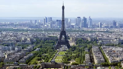
Cleaner Air In Paris? There Will Be an App for That
Cars, smartphones, and Paris’ air quality crisis.
A Call to Regulators: Do More to Protect Electricity Infrastructure
America’s electricity infrastructure is vulnerable to physical attack. And while federal regulators have known this for years, they’ve been slow to compel security upgrades.
Mapping NYC’s Taxi Redundancies
MIT’s Senseable City Lab produced a beautiful visualization of every taxi ride taken in New York City in 2011. More valuable than the pretty pictures, however, are the insights the data provide about creating a more efficient transportation system.
Evaluating the Growth of Transportation Network Companies like Uber and Lyft
Transportation network companies like Uber, Lyft, and Sidecar are growing quickly. A recent article examines the potential of such networks to build new efficiencies into urban transportation, as well as some of the risks to that potential.
Seven Apps to Improve Quality of Life in Cities
It’s no secret that more and more people are using smart phones to get the most out of their urban experiences—at home or while traveling. Guardian Cities lists some of the best urban apps and launches a contest to find the best apps worldwide.

How Smart Cities Encourage Citizen Engagement
The extent to which cities will build data collection systems into the infrastructure—or how much we’ll voluntarily gather and share information from our smartphones—has yet to be determined. Here is a survey of what some cities have launched so far.
Can OpenStreetMap Overthrow the Google Maps Hegemony?
A recent long-read describes the current state of the competition for primacy in the world of online mapping tools. The champ—Google Maps. The challenger—OpenStreetMap.
Oil and Water: Connected Cars and Privacy
Jeremy Cato pens an editorial on the dark side of connected cars—the data necessary to track and integrate so many card will allow unprecedented invasions of privacy.
Exploring Architecture with Oscar-Nominated Director Steve McQueen
Many filmmakers are concerned with set making, but not architecture. Steve McQueen, Best Director nominee for 12 Years a Slave (which is also nominated for Best Picture) has made a career of examining the role of architecture in building narrative.

Ranking the Top Movies About Urbanism
The Oscars are this weekend, so its an appropriate time to turn to movie magic as a powerful force for how American’s perceive environments—from rural to urban and everything between.
Music to the Subway Rider’s Ears
James Murphy has composed a “Subway Symphony”—a unique set of notes for each station in NYC’s Metro system that would sound when users swipe their fare cards. “The busier a station becomes, the richer the harmonies would be.”
Urban Design for Planners 1: Software Tools
This six-course series explores essential urban design concepts using open source software and equips planners with the tools they need to participate fully in the urban design process.
Planning for Universal Design
Learn the tools for implementing Universal Design in planning regulations.
Ada County Highway District
Clanton & Associates, Inc.
Jessamine County Fiscal Court
Institute for Housing and Urban Development Studies (IHS)
City of Grandview
Harvard GSD Executive Education
Toledo-Lucas County Plan Commissions
Salt Lake City
NYU Wagner Graduate School of Public Service


