


The GOP tax reform bill enabled a potentially powerful new funding mechanism for struggling communities.

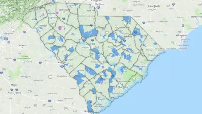
Jess Weaver shares a map from Esri that determines whether Census tracts across the country are qualified for the Opportunity Zone program, enabled by the "Investing in Opportunity Act" approved by Congress in 2017 and the tax reform package signed by President Trump into law late in 2017. The case for the Opportunity Zones as a component of the tax reform bill was also originally spearheaded by the Economic Innovation Group think tank.
The bill established Opportunity Zones, "which encourage long-term investments in low-income urban and rural communities across the country," explains Weaver. "The Opportunity Zones program provides a tax incentive for investors to re-invest their unrealized capital gains into so-called 'Opportunity Funds.' These funds apportion at least 90 percent of their capital to specific areas designated by the chief executives of every U.S. state and territory."
Jim Tankersley reports on the GOP tax reform package's role in bringing Opportunity Zones to fruition. Tankersley reports that Opportunity Zones represents the first "substantial federal attempt" to aid struggling communities in more than a decade. "If the zones succeed, they could help revitalize neighborhoods and towns that are starved for investment," writes Tankersley. "They could also deliver a windfall, in the form of avoided capital gains taxes, for corporations and financiers who invest in the Opportunity Zones."
The value of Esri's map is in informing state chief executives as they prepare to designate Opportunity Zones. The deadline for that decision was set for 90 to 120 days after December 22, 2017. The maps will also provide a valuable comparison tool after those recommendations are made.
FULL STORY: Map Monday: Opportunity Zone Qualification

New Scrutiny for the Federal 'Opportunity Zones' Program
Opportunity Zones—a new federal program that flew under the radar of the GOP tax reform bill signed at the end of 2017—has been moving along and attracting new attention from media outlets.

Oregon's 86 Opportunity Zones Include 'High Rent' Districts in Portland
Oregon is the latest state to join the nascent federal program, which is designed to stimulate investment in distressed areas.

Ohio Announces 320 'Opportunity Zones'
The new Opportunity Zones program is one to watch as states around the country throw their hats in the ring.

Alabama: Trump Terminates Settlements for Black Communities Harmed By Raw Sewage
Trump deemed the landmark civil rights agreement “illegal DEI and environmental justice policy.”

Planetizen Federal Action Tracker
A weekly monitor of how Trump’s orders and actions are impacting planners and planning in America.

The 120 Year Old Tiny Home Villages That Sheltered San Francisco’s Earthquake Refugees
More than a century ago, San Francisco mobilized to house thousands of residents displaced by the 1906 earthquake. Could their strategy offer a model for the present?

Ken Jennings Launches Transit Web Series
The Jeopardy champ wants you to ride public transit.

BLM To Rescind Public Lands Rule
The change will downgrade conservation, once again putting federal land at risk for mining and other extractive uses.

Indy Neighborhood Group Builds Temporary Multi-Use Path
Community members, aided in part by funding from the city, repurposed a vehicle lane to create a protected bike and pedestrian path for the summer season.
Urban Design for Planners 1: Software Tools
This six-course series explores essential urban design concepts using open source software and equips planners with the tools they need to participate fully in the urban design process.
Planning for Universal Design
Learn the tools for implementing Universal Design in planning regulations.
Clanton & Associates, Inc.
Jessamine County Fiscal Court
Institute for Housing and Urban Development Studies (IHS)
City of Grandview
Harvard GSD Executive Education
Toledo-Lucas County Plan Commissions
Salt Lake City
NYU Wagner Graduate School of Public Service