


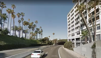
The terminus of the I-10 freeway is a 7,000-foot concrete trench across the heart of Santa Monica. The city's new downtown plan calls for a cap, and a new master plan will hammer out specifics.
Antonio Pacheco reports on the 2017 Downtown Community Plan approved by the city of Santa Monica, focusing specifically on the plan's call for a freeway cap on the terminus of the I-10 freeway.
According to Pacheco, the freeway cap "would fully transform the southern edge of the city into a civic and commercial node while also providing the city with an opportunity to rework surface streets to better accommodate the new focus on multi-modal transport."
In a separate article, Niki Cervantes reports that the process to develop the Gateway Master Plan, the planning document that would focus specifically on the cap proposal, will launch early in 2018.
Pacheco provides additional details on the current status of the project, as well as history on similar freeway cap projects proposed in Southern California in recent years.
FULL STORY: Santa Monica looks to cap Interstate 10 in new downtown plan

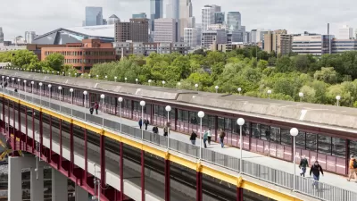
Minnesota Republicans Kill Passenger Rail, Freeway Cap Projects
Republicans in the Minnesota State Senate blocked the planning of a proposed passenger rail route between Duluth and the Twin Cities in addition to a plan for a freeway cap in a historically Black neighborhood in St. Paul.
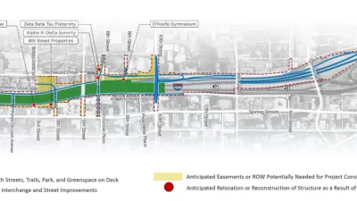
Atlanta Weighs 'Midtown Connector' Freeway Cap
The billion-dollar project would create a 25-acre park and 3.5 miles of new bike and pedestrian routes.

Reimagining the Urban Freeway
With the new administration placing racial justice and equity at the forefront of transportation policy, will America finally reckon with the legacy of its freeways?

Alabama: Trump Terminates Settlements for Black Communities Harmed By Raw Sewage
Trump deemed the landmark civil rights agreement “illegal DEI and environmental justice policy.”

Planetizen Federal Action Tracker
A weekly monitor of how Trump’s orders and actions are impacting planners and planning in America.

The 120 Year Old Tiny Home Villages That Sheltered San Francisco’s Earthquake Refugees
More than a century ago, San Francisco mobilized to house thousands of residents displaced by the 1906 earthquake. Could their strategy offer a model for the present?

In Both Crashes and Crime, Public Transportation is Far Safer than Driving
Contrary to popular assumptions, public transportation has far lower crash and crime rates than automobile travel. For safer communities, improve and encourage transit travel.

Report: Zoning Reforms Should Complement Nashville’s Ambitious Transit Plan
Without reform, restrictive zoning codes will limit the impact of the city’s planned transit expansion and could exclude some of the residents who depend on transit the most.

Judge Orders Release of Frozen IRA, IIJA Funding
The decision is a victory for environmental groups who charged that freezing funds for critical infrastructure and disaster response programs caused “real and irreparable harm” to communities.
Urban Design for Planners 1: Software Tools
This six-course series explores essential urban design concepts using open source software and equips planners with the tools they need to participate fully in the urban design process.
Planning for Universal Design
Learn the tools for implementing Universal Design in planning regulations.
Clanton & Associates, Inc.
Jessamine County Fiscal Court
Institute for Housing and Urban Development Studies (IHS)
City of Grandview
Harvard GSD Executive Education
Toledo-Lucas County Plan Commissions
Salt Lake City
NYU Wagner Graduate School of Public Service