


Houston's flooding might be mitigated by land use regulation- but not the type of regulations that most cities have.

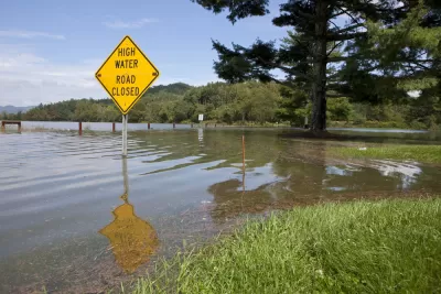
Once Houston started to flood, I saw post after post on my Facebook and Twitter feeds, all saying, in so many words, "If only Houston was more regulated,Houston would stop flooding!" (Here's one of the more persuasive examples).* Are all these posts right? Yes…and no.
To understand why, imagine two possible zoning codes: one for the pro-environment city of Ecoland, and the other for the typical American city of Usualville.
In Ecoland, preventing and mitigating flooding is the first priority. This means that the city and its neighbors would prevent flooding by prohibiting development of wetlands and by minimizing the number of impervious surfaces—that is, roads and parking lots that do not soak up rain. If there are lots of impervious surfaces, rain runs off from the impervious surfaces into bayous and rivers and dams, making those bodies of water overcrowded and more likely to flood.
But minimizing impervious surfaces requires policies that are a bit unusual. First, government would, like cities in Oregon, use zoning to create a greenbelt (or, in plannerese, "urban growth boundaries") around the city—that is, to prevent the outer edges of the region from being paved over to build more impervious surfaces. This might raise housing prices. If more people moved into the city, they would be accommodated by making the already-built-up part of the city more compact—which the city's existing residents might not like.
Second, the city would not build new roads to suburbia, because those roads encourage suburban development, which in turn means that those suburbs get paved over with parking lots and secondary roads, thus reducing the amount of grass and wetlands available to soak up rain. In addition, existing roads would be as narrow as possible, because each new lane of road is another lane of impervious surface. Of course, drivers might not like that.
Third, the city would use zoning to minimize surface parking (another impervious surface). The most coercive possible zoning code would simply outlaw surface parking lots. A more moderate code would at least abolish minimum parking requirements, leaving parking up to the market. Why? Because when government mandates parking for stores and apartments (as is the case in Houston, as well as in most of the United States) many landowners will build surface parking lots because such lots are cheaper than aboveground or underground structures. Obviously, fewer parking lots might inconvenience drivers, so this policy also might be controversial.
Fourth, Ecoland would take an ax to height and density regulations. Most zoning codes strictly limit tall buildings, and limit density by requiring houses to take up some minimum amount of land. (Houston too has density regulations, though they are a bit more lenient than those of some Sunbelt cities.) But if a city's close-in neighborhoods are dominated by big houses and short apartment buildings, the close-in areas might not have enough housing to go around—so development has to shift to places further away from downtown, which means more paving of previously rural and suburban places, which of course means more impervious surfaces. So density-phobia would have to be washed out of the zoning code.
In addition, the city’s regulations would focus on adaptation—that is, making sure that when a flood comes, people don’t drown. Normal, anti-density zoning tends to regulate height strictly, which means that most people live in single-story houses and garden apartment complexes. But single-story buildings are death traps in a flood-happy city like Houston, because people cannot flee to higher floors when a flood comes.
So under Ecoland’s zoning code, any new residential single-story buildings would have to be somehow elevated to make them taller than a typical one-story building. In the absence of such elevation, houses and apartment buildings would have to be two stories or more (at least). In addition, the code would make multistory residential buildings the norm, by eliminating regulations limiting height. Where most cities have maximum height requirements, Ecoland would have minimum height requirements.
Some urbanists believe that walk-up bulidings promote street life, and thus would oppose any building over five or six stories. But in an aging society, more and more people will be unable to use stairs. (In fact, I have friends in their mid-50s who have “stair issues” due to weak knees and other problems.) So if Ecoland residents are forced into walk-ups, many seniors would be forced to live on the death-trap first floor. To avoid this outcome, any height limit would be generous enough to accommodate mid-rise elevator buildings—say, at least 10-20 stories.
Another concern about taller buildings is that after a storm, electricity outages might eliminate elevator service, thus trapping people who cannot climb stairs in their apartments. Although this is a serious problem, it is a much less serious problem than people drowning in single-story houses or garden apartments.
So if you compare Houston to Ecoland, you might say to yourself: "Houston doesn’t have any of these rules; thus, Houston needs zoning and lots of it!"
But this view is simplistic, because no zoning code resembles that of Ecoland (though some cities in the Pacific Northwest adopt a few Ecoland-like policies). To imagine what Houston would be like with zoning, it probably makes more sense to compare Houston to other automobile-oriented cities with zoning, such as Dallas or Atlanta.
So what does the zoning code of a typical city (my hypothetical Usualville) look like?
*Government mandates that most landowners build lots of parking for their tenants and customers. This parking often comes in the form of surface parking- that is, new impervious surface. So Usualville’s zoning actually encourages flooding by encouraging the creation of new impervious surfaces.
*Density and height regulations limit close-in development, which means development is forced into new suburbs. New suburbs mean new roads and parking lots- that is, new impervious surface that means more flooding. And to the extent than Usualville’s height regulations encourage or require one- and two-story buildings, they create more buildings that are unsafe when it floods.
Usualville’s transportation policies are also pro-flooding. Usualville, like Houston, builds lots of new roads to facilitate suburban development. These new roads are of course impervious themselves. And as the road-created suburbs develop, new roads and parking lots are built for the suburbs’ new residents. And even in existing neighborhoods, road design standards may favor wide roads with wide lanes—that is, even more impervious surface.
So if Houston's hypothetical zoning was like that of a typical American city, it might not be significantly less likely to flood. But if Houston's zoning was focused on Houston's unusual weather conditions, it might do some good—although at the sacrifice of other valid public goals.
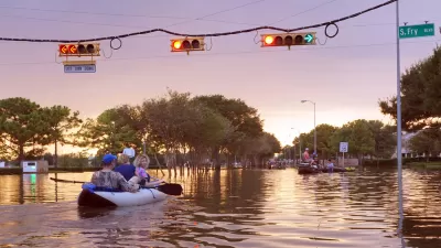
*I note that even if the right policies would prevent some floods, they might not prevent floods as large as this week's flood (see here for an argument on that side of the issue). Between 1992 and 2010, development wiped out enough wetlands to handle 4 billion gallons of water—but this week's storm is likely to drop 9 trillion gallons on Houston.

Flood Plans, Green Infrastructure Take Center Stage in Houston's Mayoral Race
The city of Houston will decide their next mayor in November, in a rematch of the two candidates who ran against each other in a tight runoff election in 2015 as well as a host of additional candidates.
Flooding Less of a Concern as Hurricane Memories Fade
Residents of Houston are less likely to think of flooding as a concern, or to think development should be prohibited in flood-prone areas, as in the years immediately following Hurricane Harvey.
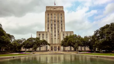
Up and Running: The Speedy Recovery of Houston's City Hall
Following Hurricane Harvey, Houston's City Hall became flooded with four feet of water, rendering the building's electrical and mechanical equipment useless. Restoring power back to City Hall quickly was crucial in aiding the recovery efforts.

Alabama: Trump Terminates Settlements for Black Communities Harmed By Raw Sewage
Trump deemed the landmark civil rights agreement “illegal DEI and environmental justice policy.”

Planetizen Federal Action Tracker
A weekly monitor of how Trump’s orders and actions are impacting planners and planning in America.

The 120 Year Old Tiny Home Villages That Sheltered San Francisco’s Earthquake Refugees
More than a century ago, San Francisco mobilized to house thousands of residents displaced by the 1906 earthquake. Could their strategy offer a model for the present?

Ken Jennings Launches Transit Web Series
The Jeopardy champ wants you to ride public transit.

BLM To Rescind Public Lands Rule
The change will downgrade conservation, once again putting federal land at risk for mining and other extractive uses.

Indy Neighborhood Group Builds Temporary Multi-Use Path
Community members, aided in part by funding from the city, repurposed a vehicle lane to create a protected bike and pedestrian path for the summer season.
Urban Design for Planners 1: Software Tools
This six-course series explores essential urban design concepts using open source software and equips planners with the tools they need to participate fully in the urban design process.
Planning for Universal Design
Learn the tools for implementing Universal Design in planning regulations.
Clanton & Associates, Inc.
Jessamine County Fiscal Court
Institute for Housing and Urban Development Studies (IHS)
City of Grandview
Harvard GSD Executive Education
Toledo-Lucas County Plan Commissions
Salt Lake City
NYU Wagner Graduate School of Public Service