


A vision set forth for Los Angeles in 1970 still has powerful relevance in 2017.

Los Angeles is stuck between a desperate need of housing and its fear of becoming a looming metropolis with even more traffic. After Measure S (a recently defeated slow growth measure), the chasm between pro-development forces and NIMBY opposition appears as wide as ever. However, a solution can be found among the planning efforts put forward by the city in years past. This solution suggests a pleasant city, with pedestrian promenades, an abundance of parks, and buildings never higher than seven stories. This solution could provide all the needed new housing stock without the additional traffic. And this solution, based on the historic "Centers Concept," gives L.A. a chance to create the second phase of its transit revolution—namely to build a city in coordination with transit.
In 1970, L.A. city planners created the "Centers Concept." The main idea was bold and simple:
- Concentrate high density development in a few activity centers.
- Connect these areas with rapid transit.
- Leave low-density areas alone.
The city adopted the plan in 1974, but many elected officials and the public at the time never bought into it. With L.A.'s unprecedented transit expansion, these concepts deserve a fresh look as a catalyst toward creating a healthier, more equitable and effective Los Angeles; with comfortable capacity for all Angelenos who cannot find enough housing supply today.
In spite of many proclamations to the contrary, L.A. remains largely suburban. While recent policy ideas attempt to right many wrongs, better policies applied to a suburb only make for a better suburb.
As far back as the 1960s, Los Angeles was starting to reach the limits of its original planning. If the majority of Angelenos can agree that L.A. needs more housing but fewer cars, then the question is: What would a Los Angeles with housing for all, but with fewer cars look like?
The answer can be found in the creation of a genuinely urban, not suburban, city, directly around—and only at—rail transit stations. Thus, the city needs to become a different city around its transit centers.
This distinction between urban and suburban is important. Urban places are vastly more efficient than suburban ones; there are no wasted spaces! In suburbia, buildings are designed and surrounded by buffer spaces, which then get either paved or landscaped. In an urban place, the open spaces—the streets, the plazas and the parks—are designed and then surrounded by buildings. Urban streets prioritize pedestrian life, with retail, restaurants, and entertainment. Folks get around on foot, on bikes, by transit rideshare, and in individual cars. They live in apartments with a living room looking out into the street and bedrooms looking into a quiet green courtyard.
Humans have designed urban places like this for centuries, and thus created much of the world's most livable cities. A graphic that best explains the concept of urban is the Nolli Plan of Rome. It shows public spaces in detail, but assembles all individual buildings into a grey background.

In an effort to make room for cars, societies switched from urban to suburban design about 100 years ago, when architects and planners designed freestanding buildings into park-like settings and connected them with roads to serve single use vehicles. There are volumes written about how that did not work out, but the appeal of freestanding buildings endures today.
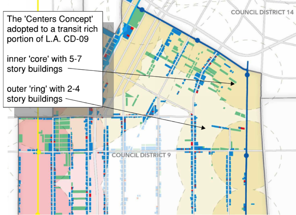
L.A. could treat each rail transit station as a "center" and develop two genuinelyurban zones around them. The inner half-mile radius would encircle the "core" zone, with buildings approximately five to seven stories tall. The "core" should include a park no smaller than 100 acres. In another half-mile ring surrounding the core, a less intense city would include buildings two to four stories tall.
Many cities have older, pre-automobile sections from which to draw inspiration. Yet, such examples barely exist in L.A. In the inner "core" areas, imagine versions of Seattle's urban villages or parts of Santa Monica or West Hollywood surrounding each station—with a pedestrian, people-centered vitality missing from many of L.A.’s streets.

In the "outer" ring, a less intense city will transition from the "centers" into the rest of Los Angeles. Models for this "outer" ring could be found in Brooklyn or the residential parts of San Francisco.

The main idea is that in the inner "core," people could walk, and in the "outer ring," people could bike, rideshare, or bus to the transit station. Outside of those "centers," L.A. would remain untouched.
Statistically, these "centers" are very small. If implemented around all 104 existing Metro stations, they would only occupy a small portion of Los Angeles County. In that area, there would be 104 100-acre parks; and vibrant urban zones that can easily accommodate everybody in L.A. with room to spare. These 104 "centers" would create a theoretical housing capacity, and office space and parks, for six to fifteen million Angelenos—on 1.65 percent of the land area in L.A. County. Future expansions of our transit network through Measure M will add additional centers, and thus additional capacity and parks. The people living in the "centers" would enjoy a more livable, pleasant city than exists now, and they would not need to drive for most of their daily lives.
City leaders may wish to build towers here or there, but the city would not need high-rises to solve a capacity problem for a very long time.
However, an existing city cannot simply start over. Some transit stations will not lend themselves to the creation of complete "centers." Often, the idealized "circles" might need to become "pieces of a pie." Reality rarely achieves the results a theoretical model promises, but applying this model to the existing city can accomplish a lot. Big visions are useful to guide and inform long-term decisions. L.A. can bend city development policy toward less traffic and make room for all its people.
City planning is already tiptoeing into the right direction with Transit Neighborhood Plans. Nevertheless, much bolder steps are needed.
Current guidelines and policies in the city of Los Angeles contradict the ideas of urbanism. This needs to change, urgently. Cities should be evolving collections of many smaller projects, developed by locals, for locals. The monster residential tower that has become the preferred investment vehicle for 'gated communities in the sky' should be the exception, not the rule.
Parking should be treated as a need to be met by the district, not individual buildings. The first question for a new residential project must no longer ask, "What are the parking requirements on my site?"
Freed again from on-site parking, L.A. could build the duplexes, triplexes and quadplexes that once made up its great old housing stock. Codes should actively encourage preferred building types commonly found in other cities. These typologies are often called "missing middle buildings," and they are indeed desperately missing in Los Angeles.
New regulations and standards must balance individual vehicles against human needs, and the humans must win. Alternatives to cars, such as busses, bikes, walking, etc. need to be abundant. Major through-roads should be rerouted around the "centers." Inside the "centers," car ownership should be de-incentivized, and the remaining parking, in smaller numbers, should exist underground, out of sight.
Finally, planning should rethink the wisdom of updating 35 community plans if those plans are disconnected from catalytic transportation opportunities. The city can be more effective by putting their focus on the transit "centers," where transit neutralizes the need for more cars.
Perhaps the city could demonstrate the "centers" concept around a single station. There are even international procedural and financial mechanisms to help make this happen.
City leadership will not easily embrace such a massive change. The people must demand it. An updated "centers" concept can unlock a truly better future. It will create room for all Angelenos to live healthy, prosperous, sustainable lives, in one of the best natural locations on earth.
This city just needs to find the political will to allow it to happen.
Detailed area calculations are available here.

Sioux Falls Multi-Family Development Outpaces Transportation Improvements
Sioux Falls, South Dakota is undergoing a multi-family development boom. Residents are increasingly concerned about the traffic the development brings, according to local news reports.
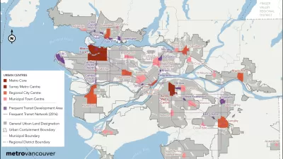
Vancouver Approves New Metro 2050 Regional Plan
The region around Vancouver in British Columbia has a new 30-year regional plan.

New Plans for Transit Oriented Development in South Central L.A.
Los Angeles County recently adopted the Florence-Firestone Transit Oriented District Specific Plan.

Alabama: Trump Terminates Settlements for Black Communities Harmed By Raw Sewage
Trump deemed the landmark civil rights agreement “illegal DEI and environmental justice policy.”

Planetizen Federal Action Tracker
A weekly monitor of how Trump’s orders and actions are impacting planners and planning in America.

The 120 Year Old Tiny Home Villages That Sheltered San Francisco’s Earthquake Refugees
More than a century ago, San Francisco mobilized to house thousands of residents displaced by the 1906 earthquake. Could their strategy offer a model for the present?

Ken Jennings Launches Transit Web Series
The Jeopardy champ wants you to ride public transit.

BLM To Rescind Public Lands Rule
The change will downgrade conservation, once again putting federal land at risk for mining and other extractive uses.

Indy Neighborhood Group Builds Temporary Multi-Use Path
Community members, aided in part by funding from the city, repurposed a vehicle lane to create a protected bike and pedestrian path for the summer season.
Urban Design for Planners 1: Software Tools
This six-course series explores essential urban design concepts using open source software and equips planners with the tools they need to participate fully in the urban design process.
Planning for Universal Design
Learn the tools for implementing Universal Design in planning regulations.
Clanton & Associates, Inc.
Jessamine County Fiscal Court
Institute for Housing and Urban Development Studies (IHS)
City of Grandview
Harvard GSD Executive Education
Toledo-Lucas County Plan Commissions
Salt Lake City
NYU Wagner Graduate School of Public Service