


A new study explores how the built environment influences vehicle miles traveled.

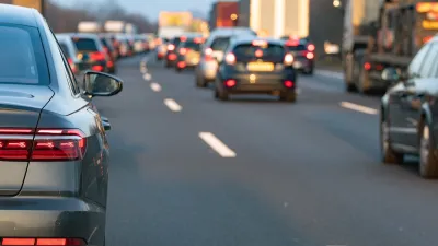
New research based in Massachusetts suggests policy action in six areas to reduce driving in the state—none of which include widening roads.
Instead, researchers at the State Smart Transportation Initiative have identified characteristics of development that factor into vehicle miles traveled:
- Land use mix (average distance between homes and the nearest retail establishment)
- Household density (households per square mile of land area)
- Sidewalk coverage (percentage of road miles with a sidewalk at least 3 feet in width)
- Transit access (average distance between homes and the nearest transit stop)
- Intersection density (number of intersections per square mile)
- Managed parking (block groups with a single-use parking structure within 1 mile scored 1, others scored 0)
"The only policy options expected to reduce 2040 passenger VMT below 2010 levels involved changes to all six variables," writes SSTI's Bill Holloway. "However, policies that adjust only a single variable could also make a significant difference."
The largest impact of any single policy change would come from increasing land use mix, which could reduce VMT by 4.3 percent.
"Siting stores and other destinations within walking distance of where people live is one of the most powerful ways to reduce car traffic," Streetsblog explains.
FULL STORY: A Six-Point Plan to Cut Traffic

Research Shows More Roads = More Driving
A national study shows, once again, that increasing road supply induces additional vehicle travel, particularly over the long run.
Opinion: Housing Versus Trees Is a False Choice; Swap Pavement for Trees Instead
Seattle’s goal to cover 30 percent of the city with tree canopy by 2037 doesn’t need to be sacrificed in favor of density. There’s a better way.
Rethinking Suburban Development: New Trends in Creating Livable Communities
Discover new trends in suburban development focused on creating more livable, sustainable communities for future growth.

Alabama: Trump Terminates Settlements for Black Communities Harmed By Raw Sewage
Trump deemed the landmark civil rights agreement “illegal DEI and environmental justice policy.”

Planetizen Federal Action Tracker
A weekly monitor of how Trump’s orders and actions are impacting planners and planning in America.

The 120 Year Old Tiny Home Villages That Sheltered San Francisco’s Earthquake Refugees
More than a century ago, San Francisco mobilized to house thousands of residents displaced by the 1906 earthquake. Could their strategy offer a model for the present?

Ken Jennings Launches Transit Web Series
The Jeopardy champ wants you to ride public transit.

BLM To Rescind Public Lands Rule
The change will downgrade conservation, once again putting federal land at risk for mining and other extractive uses.

Indy Neighborhood Group Builds Temporary Multi-Use Path
Community members, aided in part by funding from the city, repurposed a vehicle lane to create a protected bike and pedestrian path for the summer season.
Urban Design for Planners 1: Software Tools
This six-course series explores essential urban design concepts using open source software and equips planners with the tools they need to participate fully in the urban design process.
Planning for Universal Design
Learn the tools for implementing Universal Design in planning regulations.
Clanton & Associates, Inc.
Jessamine County Fiscal Court
Institute for Housing and Urban Development Studies (IHS)
City of Grandview
Harvard GSD Executive Education
Toledo-Lucas County Plan Commissions
Salt Lake City
NYU Wagner Graduate School of Public Service