


The "Monitoring Global Urban Expansion Program" gathers and analyzes data on 200 cities around the world. The "Atlas of Urban Expansion" presents the program's preliminary results.

FULL STORY: Atlas of Urban Expansion

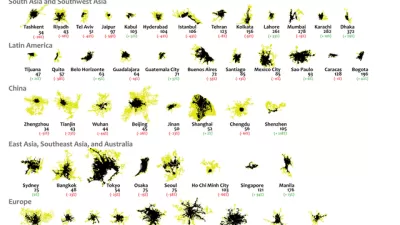
Mapping 25 Years of Urban Expansion
What comparing 25 years of urban expansion on six continents reveals about the changing nature of the built environment.
United Nations Taking First Steps Toward the New Urban Agenda
Some of the big work left undone by the Habitat III summit in finalizing the New Urban Agenda in December is now moving forward. The future of the New Urban Agenda and UN-Habitat can now start to take shape.
A New Kind of Planning for a New Kind of Africa
Ernest Harsch interviews UN-Habitat Director Joan Clos on the challenges facing African cities in an age of unprecedented urbanization, from the abundance of slums to the threat of natural disasters.

Alabama: Trump Terminates Settlements for Black Communities Harmed By Raw Sewage
Trump deemed the landmark civil rights agreement “illegal DEI and environmental justice policy.”

Planetizen Federal Action Tracker
A weekly monitor of how Trump’s orders and actions are impacting planners and planning in America.

The 120 Year Old Tiny Home Villages That Sheltered San Francisco’s Earthquake Refugees
More than a century ago, San Francisco mobilized to house thousands of residents displaced by the 1906 earthquake. Could their strategy offer a model for the present?

Ken Jennings Launches Transit Web Series
The Jeopardy champ wants you to ride public transit.

BLM To Rescind Public Lands Rule
The change will downgrade conservation, once again putting federal land at risk for mining and other extractive uses.

Indy Neighborhood Group Builds Temporary Multi-Use Path
Community members, aided in part by funding from the city, repurposed a vehicle lane to create a protected bike and pedestrian path for the summer season.
Urban Design for Planners 1: Software Tools
This six-course series explores essential urban design concepts using open source software and equips planners with the tools they need to participate fully in the urban design process.
Planning for Universal Design
Learn the tools for implementing Universal Design in planning regulations.
Clanton & Associates, Inc.
Jessamine County Fiscal Court
Institute for Housing and Urban Development Studies (IHS)
City of Grandview
Harvard GSD Executive Education
Toledo-Lucas County Plan Commissions
Salt Lake City
NYU Wagner Graduate School of Public Service