


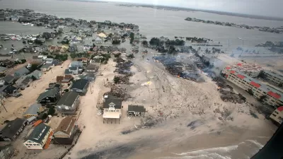
A report from the Regional Plan Association maps out what might happen under 1, 3, and 6 feet of sea level rise. In the worst cases, several dense and populated regions are affected.
Using methodology developed by the National Oceanic and Atmospheric Administration, RPA's study "outlines the impact that 1, 3 and 6 feet of sea level rise could have on the [New York] region and the immediate actions that policymakers and residents should take to protect our region's most vulnerable places."
While beach communities along Long Island and the Jersey Shore often come to mind, flooding could impact populated areas throughout greater New York. Emily Thenhaus writes, "The communities of the Rockaways, Jamaica Bay and Coney Island are among the most threatened in New York City. With 6 feet of sea level rise, a possibility as soon as early next century, much of the Rockaway peninsula could be underwater."
Rising seas may also threaten the New Jersey Meadowlands if steps aren't taken. JFK airport is mostly protected from the brunt of the floods, but LaGuardia's runways are vulnerable.
There's more to come from RPA on the region's environmental future. "The study is a component of RPA's fourth regional plan, which will be released in 2017 and will put forth policies and proposals to mitigate climate change and confront its effects."
FULL STORY: Under Water: How Sea Level Rise Threatens the Tri-State Region

Life With Climate Change: A 100-Year Storm Every Year
The extreme weather events and sea-level rise of the relatively near future will overwhelm storm and flood infrastructure with startling regularity, according to new research.
New York Flood Control Plan Takes Lessons From the Dutch
The Netherlands has a long history of flood mitigation. U.S. cities, threatened by coastal flooding and erosion, are taking note.
Opinion: One Solution to Manhattan's Land Shortage: Just Build It
A New York Times op-ed calls on the city to add landfill development on Manhattan's southern shoreline, claiming it would increase affordability and protect the city from rising sea levels.

Trump Administration Could Effectively End Housing Voucher Program
Federal officials are eyeing major cuts to the Section 8 program that helps millions of low-income households pay rent.

Planetizen Federal Action Tracker
A weekly monitor of how Trump’s orders and actions are impacting planners and planning in America.

Ken Jennings Launches Transit Web Series
The Jeopardy champ wants you to ride public transit.

Rebuilding Smarter: How LA County Is Guiding Fire-Ravaged Communities Toward Resilience
Los Angeles County is leading a coordinated effort to help fire-impacted communities rebuild with resilience by providing recovery resources, promoting fire-wise design, and aligning reconstruction with broader sustainability and climate goals.

When Borders Blur: Regional Collaboration in Action
As regional challenges outgrow city boundaries, “When Borders Blur” explores how cross-jurisdictional collaboration can drive smarter, more resilient urban planning, sharing real-world lessons from thriving partnerships across North America.

Philadelphia Is Expanding its Network of Roundabouts
Roundabouts are widely shown to decrease traffic speed, reduce congestion, and improve efficiency.
Urban Design for Planners 1: Software Tools
This six-course series explores essential urban design concepts using open source software and equips planners with the tools they need to participate fully in the urban design process.
Planning for Universal Design
Learn the tools for implementing Universal Design in planning regulations.
Ada County Highway District
Clanton & Associates, Inc.
Jessamine County Fiscal Court
Institute for Housing and Urban Development Studies (IHS)
City of Grandview
Harvard GSD Executive Education
Toledo-Lucas County Plan Commissions
Salt Lake City
NYU Wagner Graduate School of Public Service