


An interactive map from Chicago Cityscape shows all of the city's parking lots, vacant spaces, and city-owned land. Not all of it is truly vacant, or developable, but the map shows how much scope remains for new construction.
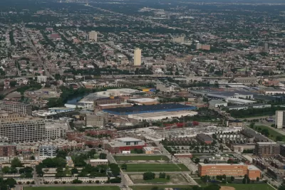
The folks over at Chicago Cityscape have upgraded their Property Finder map. According to founder Steven Vance, "The map's intention has always been straightforward: use open data to show all the land that is sitting there, across the city, but definitely concentrated in a few areas, waiting to be developed."
Categories of land include vacant spaces and portions of land owned by the city. The map also shows "over 4,600 parking lots, both surface and garage. Since the parking lots dataset comes from OpenStreetMap, where many individuals have drawn them in by hand, there are hundreds that have yet to be added."
Of course, not all the city-owned land is truly vacant, and neither is all the land labeled vacant. "The vacant land dataset, which comes from the Cook County Tax Assessor, is imperfect, too. It marks the space between buildings as vacant when they’re really not (used for driveways, garages, yards)."
Still, the map gives us an idea of where major infill development could occur. The majority of city-owned and vacant property is located in lower-income neighborhoods, both on the South Side (mostly west of the Dan Ryan Expressway), and west of downtown around Garfield Park and Lawndale. Parking lots are thickly spread south and west of the Loop, and along the river to the north.
FULL STORY: Look at all that developable land in the city

Chicago Planning Department Rejects 'Overparked' Six Corners Proposal
In a decision that is still impossible in most of the country, Chicago's Department of Planning and Development is requiring housing and reduced surface parking to approve a retail project.
Keeping Colorado Land from Development Could Cost $5 Million
In Golden, Colorado, residents want to keep a parcel of land as open space, but it could come with a hefty price tag.
Mapped: Chicago's Shrinking Middle Class
In 1970, half of the city's census tracts were middle-income. Now, only 16 percent of them remain so. Polarization between the well-off and the poor essentially splits the city in two.

Alabama: Trump Terminates Settlements for Black Communities Harmed By Raw Sewage
Trump deemed the landmark civil rights agreement “illegal DEI and environmental justice policy.”

Study: Maui’s Plan to Convert Vacation Rentals to Long-Term Housing Could Cause Nearly $1 Billion Economic Loss
The plan would reduce visitor accommodation by 25% resulting in 1,900 jobs lost.

Planetizen Federal Action Tracker
A weekly monitor of how Trump’s orders and actions are impacting planners and planning in America.

Federal Homelessness Agency Places Entire Staff on Leave
The U.S. Interagency Council on Homelessness is the only federal agency dedicated to preventing and ending homelessness.

Restoring Northern India’s Himalayan ‘Water Temples’
Thousands of centuries-old buildings protect the region’s natural springs and serve as community wells and gathering places.

Milwaukee to Double Bike Share Stations
Bublr Bikes, one of the nation’s most successful, will add 500 new e-bikes to its system.
Urban Design for Planners 1: Software Tools
This six-course series explores essential urban design concepts using open source software and equips planners with the tools they need to participate fully in the urban design process.
Planning for Universal Design
Learn the tools for implementing Universal Design in planning regulations.
Caltrans
Smith Gee Studio
Institute for Housing and Urban Development Studies (IHS)
City of Grandview
Harvard GSD Executive Education
Toledo-Lucas County Plan Commissions
Salt Lake City
NYU Wagner Graduate School of Public Service