


A new crowdsourced map projects asks people to draw their city limits from memory.
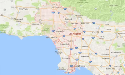
Tanvi Misra shares news of the new mapping project by Alasdair Rae, an urban scholar at the University of Sheffield, U.K., who is crowdsourcing maps of the mental boundaries of cities.
Rae's own words describe this project:
Sometimes official city boundaries extend far beyond the urban fabric, and sometimes they don't include very much of it at all. I want to see what people consider to be part of their city, or not. All the drawn boundaries on this site come from your contributions.
Yes, you can draw your own map, and, yes, you can view previous mapping attempts.
Misra notes two takeaways. First, "[f]or many, the paths they take to move around the city become its de-facto borders. M25, the highway that circles London’s core, for example, is a popular option."
Second, the "map confirms what we’ve known for a while—that how our mind recalls the space around us depends heavily on the landmarks and routes that we know and take."
FULL STORY: Where Are Your City Limits?

The Gig Economy for Mapping
A new startup wants to use blockchain and the Uber model to create free, open-source maps.
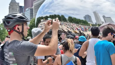
CicLAvia Tour Integrates Crowdsourcing
As cyclists toured Watts and other parts of South Los Angeles, they were invited to share photographs and record places of interest along the way.
Top 10 Free Web Applications for Planning
I had the opportuntity, at the 2009 national planning conference in Minneapolis, to present (together with my colleague Christian Peralta Madera) ten free web applications that can be used to support planning. Approximately 350 participants attended the session. Since the presentation, I've received over 100 emails congratulating us on the practical nature of the presentation, and requesting links to the websites we presented. Since our presentation was a hands-on demonstration, this blog entry outlines the ten technologies, and provides links to examples of the technology in practice and resources so you can experiment with the technologies.

Alabama: Trump Terminates Settlements for Black Communities Harmed By Raw Sewage
Trump deemed the landmark civil rights agreement “illegal DEI and environmental justice policy.”

Planetizen Federal Action Tracker
A weekly monitor of how Trump’s orders and actions are impacting planners and planning in America.

The 120 Year Old Tiny Home Villages That Sheltered San Francisco’s Earthquake Refugees
More than a century ago, San Francisco mobilized to house thousands of residents displaced by the 1906 earthquake. Could their strategy offer a model for the present?

Ken Jennings Launches Transit Web Series
The Jeopardy champ wants you to ride public transit.

BLM To Rescind Public Lands Rule
The change will downgrade conservation, once again putting federal land at risk for mining and other extractive uses.

Indy Neighborhood Group Builds Temporary Multi-Use Path
Community members, aided in part by funding from the city, repurposed a vehicle lane to create a protected bike and pedestrian path for the summer season.
Urban Design for Planners 1: Software Tools
This six-course series explores essential urban design concepts using open source software and equips planners with the tools they need to participate fully in the urban design process.
Planning for Universal Design
Learn the tools for implementing Universal Design in planning regulations.
Clanton & Associates, Inc.
Jessamine County Fiscal Court
Institute for Housing and Urban Development Studies (IHS)
City of Grandview
Harvard GSD Executive Education
Toledo-Lucas County Plan Commissions
Salt Lake City
NYU Wagner Graduate School of Public Service