


On July 25, 1916, New York adopted its first Zoning Resolution, for the first time regulating the height, size and arrangement of buildings in the city.
 "Urban lore says that the massive Equitable Building at 120 Broadway in Lower Manhattan — a 40-story extrusion of a whole city block, unrelieved by setbacks and capable of housing 16,000 workers at once — was responsible for the enactment 100 years ago, on July 25, 1916, of New York City’s first Zoning Resolution," according to the introduction of a commemorative post by David W. Dunlap.
"But while the completion of the building in 1915 added fuel, the fire was already burning. New York, it had been agreed for some time, was spinning out of control."
The article goes into more details about the political climate that created the foundation on which George McAeny and Edward M. Bassett would build the 1916 Zoning Resolution.
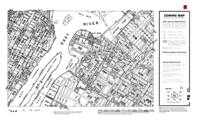
The article also includes details of exactly what regulations the resolution imposed: "Under its rules, buildings in strictly residential zones were permitted to rise only as high as the streets in front of them were wide; a ratio of one to one, put another way. (Side streets in Manhattan are typically 60 feet wide.)"
"Also visible on the maps are “1¼” zones, “1½” zones, “2” zones and, in Lower Manhattan, a “2½” zone, where buildings could rise without setback for two and a half times the width of the street that they fronted," adds Dunlap.
The article includes quotes from Carl Weisbrod, the current director of the City Planning Department and the chairman of the City Planning Commission, who talks about the many revolutionary acts of the 1916 Resolution.
The American Institute of Architects' New York chapter is also commemorating the city's zoning code with a website called Zoning@100, featuring essays and news about events connected to the 100th anniversary of the zoning code.
[Postcard depicting the Equitable Building in Manhattan, designed by Ernest R. Graham. Image via Shutterstock]
FULL STORY: Zoning Arrived 100 Years Ago. It Changed New York City Forever.

Special Permits Could Be Required for Hotel Development in New York City
Mayor Bill de Blasio is pushing ahead with a controversial approval step for hotel development, despite the warnings of city budget office staff about the long-term consequences of the move.
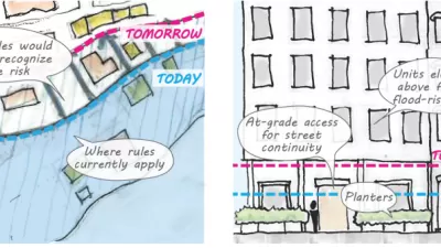
'Zoning for Coastal Flood Resiliency' Wins Planning Commission Approval in NYC
Emergency responses to Hurricane Sandy have turned into long-term lessons in New York City, as the nation's largest city crafts a response to sea-level rise and extreme weather by making changes to the zoning code of coastal areas.

New Zoning Incentives for Grocery Store Developments Proposed in New York City
Transit accessibility incentives are also included in a package of zoning reforms proposed this week that would provide incentives for grocery store developments in a wider swath of New York City.

Alabama: Trump Terminates Settlements for Black Communities Harmed By Raw Sewage
Trump deemed the landmark civil rights agreement “illegal DEI and environmental justice policy.”

Planetizen Federal Action Tracker
A weekly monitor of how Trump’s orders and actions are impacting planners and planning in America.

The 120 Year Old Tiny Home Villages That Sheltered San Francisco’s Earthquake Refugees
More than a century ago, San Francisco mobilized to house thousands of residents displaced by the 1906 earthquake. Could their strategy offer a model for the present?

Ken Jennings Launches Transit Web Series
The Jeopardy champ wants you to ride public transit.

BLM To Rescind Public Lands Rule
The change will downgrade conservation, once again putting federal land at risk for mining and other extractive uses.

Indy Neighborhood Group Builds Temporary Multi-Use Path
Community members, aided in part by funding from the city, repurposed a vehicle lane to create a protected bike and pedestrian path for the summer season.
Urban Design for Planners 1: Software Tools
This six-course series explores essential urban design concepts using open source software and equips planners with the tools they need to participate fully in the urban design process.
Planning for Universal Design
Learn the tools for implementing Universal Design in planning regulations.
Clanton & Associates, Inc.
Jessamine County Fiscal Court
Institute for Housing and Urban Development Studies (IHS)
City of Grandview
Harvard GSD Executive Education
Toledo-Lucas County Plan Commissions
Salt Lake City
NYU Wagner Graduate School of Public Service