


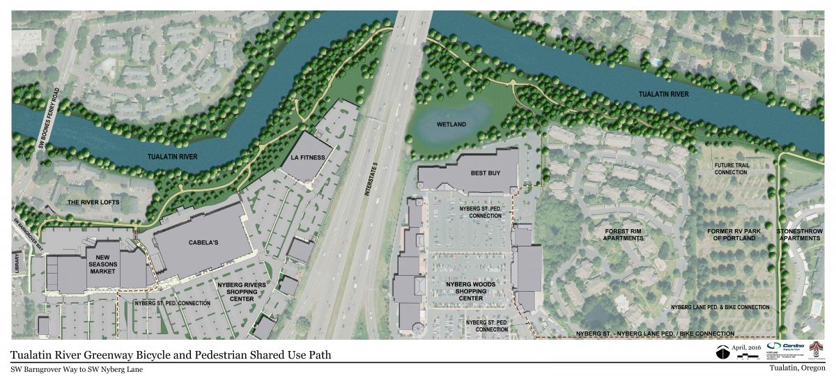
Some things are worth waiting for, including the Tualatin River Greenway Bicycle and Pedestrian Shared Use Path.

"More than three decades ago, parks planners started talking about and planning for the Tualatin River Greenway Bicycle and Pedestrian Shared Use Path," according to an article by Allan Brettman. "In all the years since, a grand total of 4.7 miles of trail have been developed along the river, stretching from Tigard to Durham and Tualatin."
Last April, a three-quarter mile section of the Tualatin River Greenway Bicycle and Pedestrian Shared Use Path opened to the public. The new stretch "not only provides a smooth, wide path next to the river but also offers a lesson on the geologic history of the Willamette Valley," according to Brettman. That history lessons spans an 18,000-year "geologic journey from the Ice Age to pioneer settlement in the Willamette Valley, with creative use of crushed blue glass, and footprints representing mastodon's and the first native Americans to settle the area."
"Geologic time is also marked by black granite bands that label the years of eruptions for Mount St. Helens and Mount Mazama – predecessor to Crater Lake," adds Brettman.
FULL STORY: Inch by glacial inch, Tualatin River Greenway became reality

Detroit Opens Segment of Joe Lewis Greenway
The newly opened segment, which features playground equipment and public lawns, is part of a 27.5 mile greenway that will loop through four cities.

Study: Recreational Trails Program Underfunded by Over $200 Million
FHA research shows that multi-use trail users contribute three times as much in gas taxes as the program to build and maintain them receives.

Baltimore's 'Big Jump'
A temporary bike and pedestrian path is changing the street design game in Baltimore.

Alabama: Trump Terminates Settlements for Black Communities Harmed By Raw Sewage
Trump deemed the landmark civil rights agreement “illegal DEI and environmental justice policy.”

Planetizen Federal Action Tracker
A weekly monitor of how Trump’s orders and actions are impacting planners and planning in America.

The 120 Year Old Tiny Home Villages That Sheltered San Francisco’s Earthquake Refugees
More than a century ago, San Francisco mobilized to house thousands of residents displaced by the 1906 earthquake. Could their strategy offer a model for the present?

Ken Jennings Launches Transit Web Series
The Jeopardy champ wants you to ride public transit.

BLM To Rescind Public Lands Rule
The change will downgrade conservation, once again putting federal land at risk for mining and other extractive uses.

Indy Neighborhood Group Builds Temporary Multi-Use Path
Community members, aided in part by funding from the city, repurposed a vehicle lane to create a protected bike and pedestrian path for the summer season.
Urban Design for Planners 1: Software Tools
This six-course series explores essential urban design concepts using open source software and equips planners with the tools they need to participate fully in the urban design process.
Planning for Universal Design
Learn the tools for implementing Universal Design in planning regulations.
Clanton & Associates, Inc.
Jessamine County Fiscal Court
Institute for Housing and Urban Development Studies (IHS)
City of Grandview
Harvard GSD Executive Education
Toledo-Lucas County Plan Commissions
Salt Lake City
NYU Wagner Graduate School of Public Service