


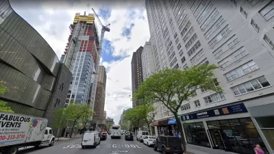
New York's 1916 zoning code would not have allowed 40 percent of buildings in Manhattan to be built today, according to a recent analysis. It also turns 100 on August 27 of this year.
"New York’s zoning code was the first in the country, meant to promote a healthier city, which was then filling with filthy tenements and office towers," write Quoctrung Bui, Matt A.V. Chaban, and Jeremy White for The New York Times' "Upshot."
That assessment is reinforced in the introduction of a May 20 Wall Street Journal book review, "In Praise of Urban Sprawl," regarding Joel Kotkin's The Human City: "The New York Times in 1898 spoke of 'densely crowded quarters' and 'inmates . . . huddled together in their cramped hutches like rabbits',” writes Shlomo Angel. Zoning codes sought to improve city living conditions without having to resort to the sprawl that Kotkin praises. [See book review of "The Human City" by Planetizen contributor, Josh Stephens.]
"Since it was approved in 1916, the ever-evolving, byzantine code has changed many times to suit the needs of a swollen metropolis," write Bui, Chaban, and White.
Just in March, the administration of Mayor Bill de Blasio won approval for a vast citywide plan that would encourage sleeker, more affordable developments. As the zoning code enters its second century, it is worth considering the ways it has shaped the city; whether and where it is still working; and how it might be altered so the city can continue to grow without obliterating everything New Yorkers love about it.
The 40 percent finding comes from an analysis made by Quantierra, "a real estate firm that uses data to look for investment opportunities."
Many buildings in distinctive Manhattan neighborhoods like Chinatown, the Upper East Side and Washington Heights could not be erected now: Properties in those areas tend to cover too much of their lots (Washington Heights), have too much commercial space (Chinatown) or rise too high (the Upper East Side). Areas like Chelsea, Midtown and East Harlem, on the other hand, would look much as they do already.
“Look at the beautiful New York City neighborhoods we could never build again,” said Mr. Stephen Smith, a co-owner of Quantierra. “It’s ridiculous that we have these hundred-year-old buildings that everyone loves, and none of them ‘should’ be the way they are.”
The reporters describe the various attractive buildings, with photos, that predate the 1916 zoning code, and the reasons why city planners altered the zoning code to make those buildings illegal. They consider the downside of the ever-more restrictive zoning codes. Explore Manhattan on this interactive map by placing your browser over areas and see which of four reasons would prevent existing buildings from being constructed.
"In honor of the code’s 100th anniversary, the Municipal Art Society of New York has called on City Hall to consider overhauling the code in a way that would make it intelligible to all," write Bui, Chaban, and White. See related Planetizen post in 2011.
“To understand zoning, you have to have a law degree, it’s so convoluted and so dense,” Mike Ernst, director of planning at the civic group, said. “The whole process of how buildings get built these days is so confusing and opaque to people. There really should be more transparency, so people can have an understanding of what the future holds for their city.”
FULL STORY: 40 Percent of the Buildings in Manhattan Could Not Be Built Today

Court Will Decide Whether to Reduce NYC Skyscraper's Height
The new skyscraper being built at 200 Amsterdam Avenue in Manhattan might be forced by an appeals court to remove 20 floors of the mostly complete building.
A New Generation of Community-Led Planning in New York
With a benchmark success in demanding rights for the community during an ongoing rezoning process in Inwood, a neighborhood in Manhattan, a new generation of community-led resistance to top-down planning is coalescing in New York City.
Advocates Push for Gowanus Rezoning, Stuck in COVID-19 Limbo, to Move Forward
According to advocates, the relative affluence of Gowanus is the reason a plan to rezone the neighborhood must move forward.

Alabama: Trump Terminates Settlements for Black Communities Harmed By Raw Sewage
Trump deemed the landmark civil rights agreement “illegal DEI and environmental justice policy.”

Planetizen Federal Action Tracker
A weekly monitor of how Trump’s orders and actions are impacting planners and planning in America.

The 120 Year Old Tiny Home Villages That Sheltered San Francisco’s Earthquake Refugees
More than a century ago, San Francisco mobilized to house thousands of residents displaced by the 1906 earthquake. Could their strategy offer a model for the present?

Ken Jennings Launches Transit Web Series
The Jeopardy champ wants you to ride public transit.

BLM To Rescind Public Lands Rule
The change will downgrade conservation, once again putting federal land at risk for mining and other extractive uses.

Indy Neighborhood Group Builds Temporary Multi-Use Path
Community members, aided in part by funding from the city, repurposed a vehicle lane to create a protected bike and pedestrian path for the summer season.
Urban Design for Planners 1: Software Tools
This six-course series explores essential urban design concepts using open source software and equips planners with the tools they need to participate fully in the urban design process.
Planning for Universal Design
Learn the tools for implementing Universal Design in planning regulations.
Clanton & Associates, Inc.
Jessamine County Fiscal Court
Institute for Housing and Urban Development Studies (IHS)
City of Grandview
Harvard GSD Executive Education
Toledo-Lucas County Plan Commissions
Salt Lake City
NYU Wagner Graduate School of Public Service