


Containing more than 500 open datasets, GeoHub lets users access the wealth of data Los Angeles makes available. The tool is also intended to help employees from different city departments work together.
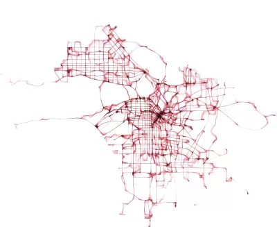
Early this year, the city of Los Angeles made public a new data visualization tool called GeoHub. Josh Cohen writes, "GeoHub is a searchable directory of over 500 eclectic L.A. city datasets such as farmers markets, emergency services, construction projects, streams and rivers, volunteer opportunities, crime, performing arts centers, and many more."
Catherine Geanuracos, a civic hacker and member of L.A.'s innovation and performance commison, remarked, "'When Mayor Garcetti took office, he started moving forward with open data. This is the next step on that from the city.'" Geanuracos went on, "The city of L.A. has been extremely siloed. Anything that prompts collaboration will be really valuable for the city overall, whether it's planning or evaluation."
L.A.'s deputy chief data officer Lillian Coral hopes GeoHub can be useful to an "engaged citizenry" of journalists, advocates, and others who may lack the time or technical acumen to decipher open data in its raw form.
FULL STORY: L.A. Opens Up More With New Data Tool

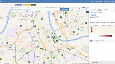
Presenting Municipal Data in an Interactive Map, Nashville Style
The city of Nashville launched the NashView interactive data map earlier this month.

DataUSA: An Intuitive Tool for Public Data
A collaboration between Deloitte, Datawheel, and MIT has produced an intuitive aesthetically-pleasing gathering point for public data in the United States. Specific locations and industries boast easy-to-read profiles.

Mapping the Age of Every Building in Los Angeles
Developed using open data from local government sources, built: LA is a mapping tool that displays the age of every building in the county. Much of the area's built environment is surprisingly old.

Alabama: Trump Terminates Settlements for Black Communities Harmed By Raw Sewage
Trump deemed the landmark civil rights agreement “illegal DEI and environmental justice policy.”

Planetizen Federal Action Tracker
A weekly monitor of how Trump’s orders and actions are impacting planners and planning in America.

The 120 Year Old Tiny Home Villages That Sheltered San Francisco’s Earthquake Refugees
More than a century ago, San Francisco mobilized to house thousands of residents displaced by the 1906 earthquake. Could their strategy offer a model for the present?

In Both Crashes and Crime, Public Transportation is Far Safer than Driving
Contrary to popular assumptions, public transportation has far lower crash and crime rates than automobile travel. For safer communities, improve and encourage transit travel.

Report: Zoning Reforms Should Complement Nashville’s Ambitious Transit Plan
Without reform, restrictive zoning codes will limit the impact of the city’s planned transit expansion and could exclude some of the residents who depend on transit the most.

Judge Orders Release of Frozen IRA, IIJA Funding
The decision is a victory for environmental groups who charged that freezing funds for critical infrastructure and disaster response programs caused “real and irreparable harm” to communities.
Urban Design for Planners 1: Software Tools
This six-course series explores essential urban design concepts using open source software and equips planners with the tools they need to participate fully in the urban design process.
Planning for Universal Design
Learn the tools for implementing Universal Design in planning regulations.
Clanton & Associates, Inc.
Jessamine County Fiscal Court
Institute for Housing and Urban Development Studies (IHS)
City of Grandview
Harvard GSD Executive Education
Toledo-Lucas County Plan Commissions
Salt Lake City
NYU Wagner Graduate School of Public Service